
Density Uplifts, Station-Led Growth, and How LandTech Gives You the Advantage
After a robust consultation (20,572 responses were received to the draft NPPF consultation), eight months and one new prime minister later, the government’s proposed revisions to the National Planning Policy Framework (NPPF) have landed.
In the words of top Planorak, Zack Simons: the 2026 NPPF is: “the most powerful, coherent, and quietly revolutionary national planning policy we’ve ever had”.
When compared to December’s consultation draft, what’s changed in the final version? If you want a line by line analysis, Simon Ricketts has provided a tracked-change version here, along with his own commentary.
While there are changes, most of them seem to be tweaks to criteria, rather than wholesale policy pivots. Most significantly:
- The National Decision Making Policies (NDMPs) in the NPPF still take priority over local plan policies (where these policies are materially different, and when they were assessed under previous versions of the NPPF)
- The policies will place sustainable connectivity and land optimisation at the heart of decision-making by opening up land around well-connected train stations.
Rather than provide my own lukewarm takes on the impact of the new NPPF, I’m going to focus today on what the changes mean for LandTech’s customers, and how we’ve been able to adapt the data and the tools that we have to accommodate the changes.
Key Highlights
- The 2026 NPPF has now been published following an eight-month consultation period that received 20,572 responses.
- Land within 800 metres of a well-connected train station now receives strong policy backing, including exemption from the need to prove "exceptional circumstances" for Green Belt boundary changes.
- The qualifying Travel to Work Area (TTWA) threshold has expanded from the top 60 to the top 80 regions by GVA, opening up thousands of additional potential sites.
- A new mandatory density floor applies near stations: 35 dwellings per hectare as standard, rising to 45+ dph at high-frequency hubs (8+ trains an hour).
- National Decision-Making Policies (NDMPs) continue to take precedence over local plan policies where they materially differ.
- LandTech has updated its Train Station Data Layer, launched a new Density Uplift Layer, and introduced a Policy Checker to help developers assess site viability against the new rules.
Shift 1: Station-Led Development Gets the Green Light
Under new policies (GB3, GB7, and S5), land located within a "reasonable walking distance" - defined as 800 metres (~10 minutes’ walk) - of a well-connected station receives strong policy backing.
Key takeaways for developers include:
- Bypassing Green Belt Hurdles: Local planning authorities no longer need to prove "exceptional circumstances" to adjust Green Belt boundaries around well-connected stations.
- Not Inappropriate Development: Major housing schemes within 800m of these hubs are no longer classed as inappropriate in the Green Belt, provided they meet key criteria and adhere to the new "Golden Rules" for affordable housing and community benefit.
- Broader Connectivity Definition: The threshold for qualifying Travel to Work Areas (TTWAs) has expanded to the top 80 regions by GVA, unlocking thousands of potential sites across the country.
Under new policies (GB3, GB7, and S5), land located within a "reasonable walking distance" - defined as 800 metres (~10 minutes’ walk) - of a well-connected station receives strong policy backing.
How LandTech Helps: The Train Station Data Layer
Our ‘Train Station Connectivity’ layer has been available for several months already. We’ll be updating this layer in the coming days to accommodate the land around the additional stations now picked up by the expansion of the TTWA criteria from the top 60 to the top 80.
We will continue to filter the sites around the most connected train stations to remove land that is subject to ‘red-flag’ constraints such as Flood Zones 2 and 3, and (using the new ‘predictive’ agricultural land classifications), Best and Most Versatile agricultural land.
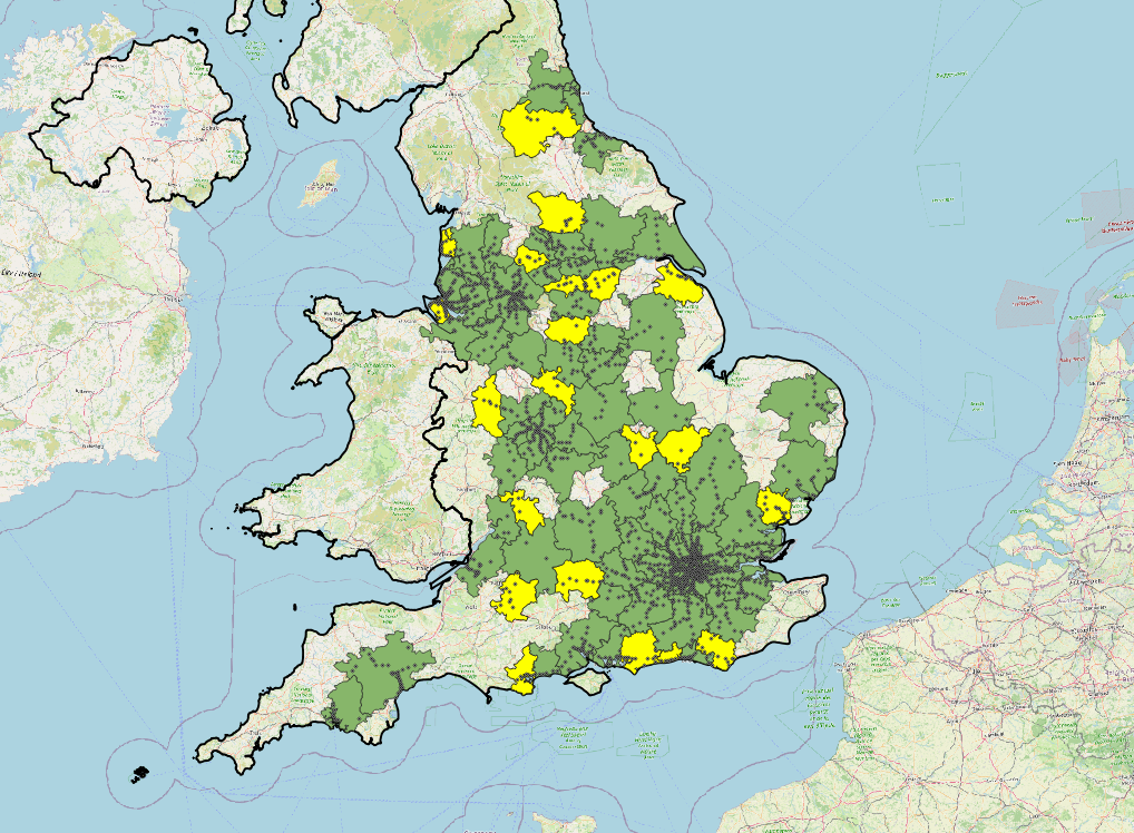
Figure: Train Stations within the top 80 TTWAs (TTWAs 60 - 80 shown in yellow)
Shift 2: Mandatory Density Floor (35-45+ Dwellings Per Hectare)
Policy S4 continues to support development within Settlements by applying the presumption in favour across the board in these areas. Although the final version of the NPPF has included an updated definition of Settlement, which excludes villages that are ‘washed-over’ by Green Belt. For settlements that are not in the Green Belt, this policy now provides an expectation that new developments will be approved. In addition to this, Policy L3 introduces a clear mandate: land within reach of transit nodes must work harder.
The consulted-on targets for density were 40 dph in near stations in settlement boundaries and 50 dph in well-connected areas. These have all been watered down in response to the consultation. The density minimums that apply now are:
- 35 dph Minimum: Standard threshold for residential and mixed-use developments in locations within 800m of a train station.
- 45 dph High-Frequency Target: Mandated for hubs with at least 8 trains an hour, or four in any one direction (i.e. double the baseline service frequency for ‘well-connected’ locations).
- Infill and Urban Density Push: A general requirement for developments within settlements to increase prevailing densities unless strictly unfeasible.
This policy shift directly impacts site yield calculations, land valuation models, and gross-to-net developable area assessments.
How LandTech Helps: The New Density Uplift Layer
Launching alongside the new NPPF updates, LandTech’s new Density Uplift Layer allows you to instantly visualise where capacity increases are legally backed by policy. With our new layer, you can identify existing low-density plots or allocated sites where density can be scaled up to 35 dph or 45+ dph in line with Policy S4 and L3.
Shift 3: De-Risking Decisions with National Decision-Making Policies
With National Decision-Making Policies now setting clear statutory expectations across England, ensuring a site passes policy muster at the pre-application stage is crucial.
How LandTech Helps: The New Policy Checker
Navigating complex updates across housing land supply, flood risk, heritage, and Green Belt rules can be time-consuming. LandTech’s new Policy Checker automates site risk assessments against the National Decision-Making Policies:
Automated Red-Flagging: Instantly cross-examine your pipeline sites against policies governing Green Belt Golden Rules (GB8), flood zones (F4-F7), and station proximity rules (S5/GB7).
- Decision Certainty: Evaluate whether an unallocated site meets the criteria for presumption in favor of sustainable development before spending on pre-application advice.
Summary Table: NPPF Policy Shift vs. LandTech Solution
|
NPPF Policy Focus |
Key Policy Change |
LandTech Tool & Solution |
|---|---|---|
|
Station-Led Growth (Policy GB3, GB7, S5) |
800m buffers around well-connected stations exempt from standard Green Belt/settlement restrictions. |
Train Station Data Layer: Maps qualifying station catchments, service frequencies, and GVA TTWA ranks automatically. |
|
Density Optimisation (Policy L3) |
Mandatory baseline of 35 dph (or 45+ dph for high frequency) near stations; general push for higher density in settlements. |
Density Uplift Layer: Highlights sites ripe for density increases and recalculates potential unit yields. |
|
National Decision-Making (DM1–DM10) |
Streamlined, unified national policies taking precedence over outdated local policies. |
Policy Checker: Instantly benchmarks pipeline sites against the latest decision-making standards. |
Ready to Find Your Next NPPF-Compliant Site?
The changes to the NPPF will redefine land promotion and development strategies for years to come. By combining spatial intelligence with real-time policy tracking, LandTech ensures you stay ahead of the curve.
Explore the updated Train Station Data Layer, test the new Density Uplift Layer, and run your pipeline through the Policy Checker in LandInsight soon.