Discover why teams switch from Searchland to the LandTech ecosystem.

Point solutions like Searchland only tell half the story. If you’re tired of hitting the ceiling of what your current software can do, join the land professionals that upgraded to LandTech.

Get deeper data, more accurate ownership insights, and a seamless workflow that scales with your ambition, not against it.

Who Uses LandTech

Built for every professional in the development journey

 
Whether you're sourcing sites, assessing them, or managing a team across both — LandTech is built around your workflow.
MOST POPULAR

Property Developers

 
  • Find the right sites faster — with precision sourcing that cuts through noise

  • Assess planning risk, policies and local comps instantly in one view

  • Contact landowners directly and track every outreach

  •  Access appraisal tools and debt advisory without leaving the platform 

 
Land Agents

Land Agents & New Homes

  • Source off-market sites that match your client brief, faster
  • Assess planning history and constraints at a glance
  • Manage full site pipelines with team assignment and Kanban views
  • Share sites and collaborate with clients and colleagues  
 
RENEWABLES

Power Developers

  • Find and assess substation proximity and grid capacity in one view
  • Spot policy constraints and red flags before committing budget
  • Manage community engagement — built for the realities of planning pushback
  • Manage the full process with a customisable pipeline 
 
Full Comparison

Every capability, side by side

An honest look at what each platform offers — and where LandTech goes further.
LandTech
Searchland

Site Sourcing & Map

Interactive map with 42+ data layers

7 themed categories — General, Policy, Strategic, Environmental, People &
Places, Traffic, Power

Grey Belt favourability scoring

More / average / less favourable — expert methodology, not raw data.
LandTech exclusive

Natural language AI site sourcing

Describe your brief in plain English — smart filters generated instantly

5-year housing land supply & housing delivery test

Site allocations, SHLAA, settlement boundaries

Land assembly, KML import, polygon draw, bulk upload

Site Assessment & Intelligence

AI planning history summary

Reads and interprets planning sentiment and outcomes in seconds — not keyword search

Quick Insights — instant site de-risking

Planning risk, policy constraints, local demand and comps — summarised in one view

Structured Policies assessment tab

13 constraint types, filterable — each with source & date

Environmental & Power assessment tabs

Flooding, BNG, agricultural land, substations and DNO — structured, not just mapped

Hometrack valuations, rental & sold price data

Verified valuations and rental estimates — in-depth comparables data

Planning application history & alerts

On-site + nearby with configurable buffer, description search and filters

Ownership, corporate hierarchy & title deeds

Flood risk, BNG, heritage & constraint overlays

Demographics, EPC, VOA, residential comparables

Workflow & Pipeline Management

Assessment & pipeline management in one panel

Assess a site and manage it without switching tools 

Site sharing with collaborator permissions

Kanban pipeline, custom stages & team assignment

Direct-to-vendor letter sending

Integrated into the site panel — no separate tool needed 

Drawing, annotations, measurement tools

Mobile app — field-ready site management

Ecosystem & Advisory

Debt advisory & finance (LandFund)

Access to lenders matched to your scheme — not just a viability calculator

Community engagement (Give My View)

De-risk planning applications before you submit

BNG report (BNGAi) — Defra-compliant

Ordered directly from the site panel — scenario planning included

add-on

Utilities report (AtkinsRealis)

Professional assessment ordered direct from your site panel

add-on

Financial appraisal tool

add-on
add-on

Three things Searchland can't match

AI search

Signal, not noise

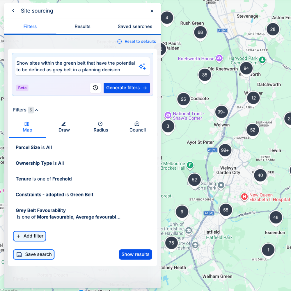
More data doesn't mean better sites. Grey Belt favourability, declassified Green Belt layers, and AI-powered filtering help you identify winnable land - so your team spends time on opportunities, not elimination.
AI Planning

Stop reading, start deciding

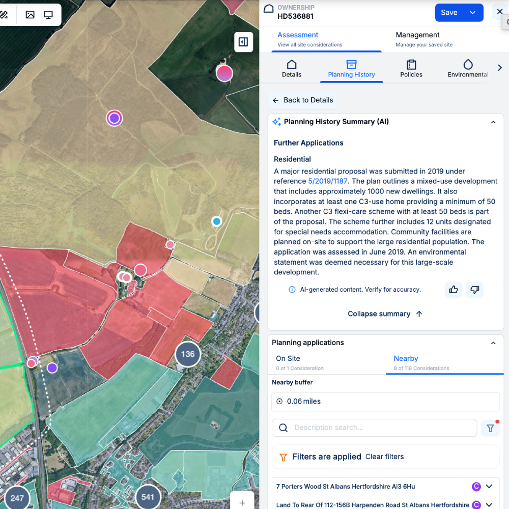
Raw data layers tell you what's there. LandTech tells you what it means. AI Planning Summaries, Quick Insights and structured assessment tabs turn complex data into clear decisions - in seconds, not hours.
LT animated graphic still

Beyond the platform

LandFund connects you with the right lenders for your scheme. Give My View manages community risk before you submit. Our specialist report marketplace handles BNG, utilities and more - all from one place.
Only On LandTech

Capabilities Searchland simply doesn't have

house

Grey Belt Favourability Scoring

Expert-built classification of winnable Grey Belt opportunities, not raw data
AI Planning Summary

AI Planning Summary

Interprets planning sentiment and outcomes in seconds, not keyword search
Quick Insights

Quick Insights

Planning risk, policies, comps and flood risk de-risked in a single structured view
pin-home

Hometrack Comparables

In-depth valuations and rental estimates beyond standard HMLR data
cash

LandFund Debt Advisory

Access to lenders matched to your asset class, not just a viability calculator
Give My View

Give My View

Community engagement built to de-risk planning applications before you submit

Helping teams move faster, with confidence.

“We have found LandTech to be a fantastic platform. Not only has it improved the speed of initial site reviews, saving us time and ensuring we can move faster with landowners, but the constraints and opportunities insights they offer are now a fundamental part of our site-finding process.”
Mike Burton
Land Director, Metis Homes
Testimonial - Metis Homes

Start finding better sites today.

Book a 30-minute demo and we'll show you exactly what the difference looks like for your workflow.
Request your demo