If you work in land or property development, you’ve probably heard the term Biodiversity Net Gain (BNG) more times this year than you can count. And for good reason: although BNG has long been one of many policy asks in some local plans, as of 2024 BNG is required by law. This means it’s no longer negotiable.
Under the Environment Act 2021, developers in England are now legally required to deliver a minimum 10% increase in biodiversity on or off-site when carrying out most new developments.
But what does that really mean in practice, and how can you make sure you’re meeting requirements without slowing down your project?
Let’s break it down.
What Is Biodiversity Net Gain (BNG)?
Biodiversity Net Gain is all about leaving the natural environment in a better state than before. In planning terms, that means your development must improve the quality and quantity of habitats by at least 10% compared to what was originally there.
You’ll need to submit a baseline biodiversity assessment as part of your planning application, and then demonstrate how your proposed works will achieve that uplift, either on-site or off-site, using biodiversity credits.
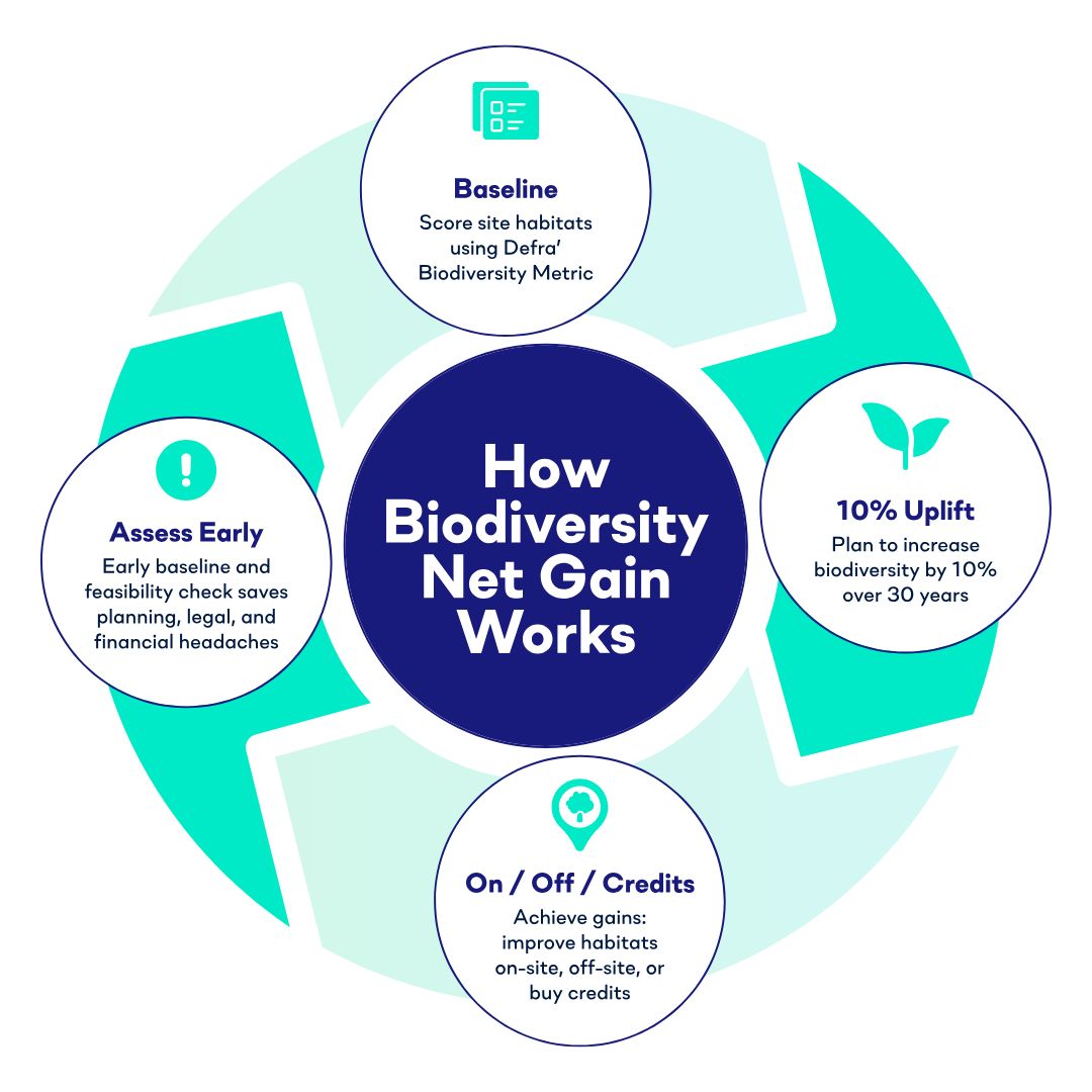
How the Environment Act Works
The Environment Act made BNG a legal requirement for most developments in England. It uses Defra’s Biodiversity Metric - a standardised system that assigns “biodiversity units” based on the type, condition, and location of habitats.
These units are what you’ll use to measure your before and after. Even if your proposed development doesn’t result in a loss of biodiversity, you’ll still need to deliver a 10% compensatory uplift in biodiversity value compared to the baseline, either through creating new habitats or improving the condition of existing ones on-site, habitat creation off-site, or purchasing biodiversity credits.

What Are Biodiversity Credits?
Not every development site can hit that 10% biodiversity uplift on-site. In dense urban locations or constrained brownfield plots, it might simply not be feasible. That’s where biodiversity credits come in.
Biodiversity credits are a market-based system that lets developers offset biodiversity losses by investing in habitat creation or enhancement projects elsewhere. Each credit represents a measurable biodiversity unit - so when you buy credits, you’re funding real, tangible ecological improvements in another location.
There are two main types:
- Private credits - bought directly from landowners or habitat banks who have created new habitats.
- Statutory credits - purchased from the government (as a last resort) when no local options exist.
Using credits doesn’t mean bypassing your responsibilities; it’s simply another tool to ensure developments achieve no net loss, and ideally, net gain for nature overall.
How BNG Works
The process starts by calculating a site’s biodiversity baseline using the Defra (Department for Environment, Food & Rural Affairs) Statutory Biodiversity Metric - a tool developed by Natural England to score habitats based on their type, size, distinctiveness, and condition.
Once the baseline is established, developers must demonstrate how their proposed development will increase the site’s overall biodiversity value by at least 10% over 30 years.
That uplift can be achieved in three ways:
- On-site gains - Enhancing or creating new habitats within the site boundary.
- Off-site gains - Securing biodiversity improvements on other land.
- Statutory biodiversity credits - Purchasing government-issued credits when on- or off-site gains aren’t feasible.
Each approach has its own planning, legal, and financial implications - which is why getting a clear baseline and feasibility assessment early is so important.
BNG And The Planning Process
Understanding when and how to submit BNG information is essential if you want your project to stay on track.
To secure planning permission, developers must now factor Biodiversity Net Gain into the planning process - with submissions required at two key stages:
- When applying for planning permission (validation), and
- After permission is granted but before development begins (approval)
At the validation stage, most local planning authorities (LPAs) expect a draft Biodiversity Gain Plan. This should show your site’s current biodiversity (the baseline), your proposed uplift (on-site or off-site), and the data behind it - all using the Statutory Biodiversity Metric. Submitting more than the legal minimum improves your chances of a smooth validation.
Your draft Biodiversity Gain Plan should ideally include:
- A pre-development habitat map and survey
- A post-development habitat map or landscape plan
- A completed Statutory Biodiversity Metric calculation
- Condition assessment sheets
- A draft Habitat Management and Monitoring Plan (HMMP)
- Supporting documentation, such as justifications for habitat types and selected conditions, along with target notes, site photos, and any relevant consultation records (if applicable)
Once planning permission is granted, a full Biodiversity Gain Plan must be submitted and approved before any development begins. This includes finalised biodiversity gains, long-term legal agreements, and detailed plans for habitat creation and monitoring.
Watch our quick video guides on what LPAs expect and how to avoid common BNG pitfalls.
These documents form part of the planning application and must be signed off before development can begin. Getting this right early helps avoid delays, redesigns, or rejected applications - and sets your project up for long-term success.
Why BNG Matters for Developers
At first glance, BNG might seem like just another compliance hurdle. But in reality, it’s driving a fundamental shift in land strategy.
Aside from being a legal requirement, BNG has real commercial value. For developers who act early, BNG can be a competitive advantage:
- Sites with clear biodiversity uplift potential will move faster through planning.
- Strong early data reduces the risk of costly redesigns or planning refusals.
- Developers who integrate BNG thinking can demonstrate ESG value to investors, partners, and local authorities.
In short, you’re showing that your business is building responsibly, not just profitably.
The Challenge: Getting Reliable BNG Data Early
One of the biggest frustrations for developers is timing. Getting a baseline biodiversity assessment can take time, especially when you’re relying on ecologists, site visits, and slow manual reporting.
To assess BNG properly, you need accurate habitat data, often before you’ve even purchased or optioned a site. Traditional ecological surveys can take weeks, depend on seasonal conditions, and come with significant costs, especially at the feasibility stage.
That’s where remote sensing and AI technology are changing the game.
Introducing BNGAI™ by AiDASH: Smarter, Faster Site Assessments
LandTech has partnered with AiDASH, a leading AI company using a SatelliteFirst approach, to make BNG assessments faster, simpler, and more accessible - directly within LandInsight.
Using commercial-grade satellite imagery and machine learning, AiDASH’s BNGAI platform helps developers manage Biodiversity Net Gain from feasibility to final submission. The platform automatically identifies and classifies habitats across your site and produces automated Defra-compliant reports. This means you can:
- Get a fast view of your biodiversity baseline - no waiting for manual surveys.
- Screen multiple sites in minutes to identify those with the best potential uplift.
- Reduce survey costs and delays, especially at the early appraisal stage.
- Make more informed decisions about where and how to deliver your 10% gain.
With BNGAI™, you can de-risk planning and avoid costly surprises that can lead to delays or redesigns later.
For developers, this integration means you can move from site sourcing to biodiversity assessment in one platform, bringing ecological data into the same workflow as ownership, constraints, planning history, and comparables.
It’s a smarter, data-driven approach to BNG that helps you find and assess sites with confidence.
See BNGAI™ in Action
You can now explore BNGAI within LandInsight, as part of our wider LandIntelligence ecosystem.
If you’re ready to make biodiversity part of your site strategy and not a last-minute hurdle, now’s the time to see what’s possible.
Book a demo or try BNGAI™ with 50% off your first order to get started.