
The idea of grey belt land was initially introduced within the December 2024 National Planning Policy Framework (NPPF) update.* Then in early 2025, the UK government published new planning practice guidance (PPG), which added more detail around this concept.**
This update provided more clarity for people interested in developing potential grey belt sites, which is why it’s so important for developers to understand the nuances of this policy.
This article breaks down the concept of grey belt land, what’s in the updated PPG, and how developers can find these new development opportunities.
Key Highlights
- Grey belt refers to parts of the Green Belt that make only a weak contribution to core Green Belt purposes and are free from Footnote 7 constraints.
- The PPG update clarifies how councils and developers should assess grey belt sites. It sets out requirements around Green Belt purposes, sustainability, and the Green Belt Golden Rules.
- Development on grey belt land can be appropriate so long as proposals meet policy criteria, including: demonstrating local need, protecting wider Green Belt functions, and proving that the site is close to transport links and supports residential needs.
- Developers must take a strategic, evidence-led approach to grey belt opportunities. This involves evaluating site characteristics, ensuring policy compliance, considering potential constraints, and aligning with housing delivery requirements.
- LandTech enables developers to identify and assess grey belt sites quickly. It uses mapped criteria and live planning data to focus resources on the most viable opportunities.
What is 'Grey Belt' Land?
The concept of grey belt land was introduced to unlock development opportunities within the Green Belt without compromising its protective purposes.
The NPPF defines grey belt as ‘land in the Green Belt comprising previously developed land and/or any other land that, in either case, does not strongly contribute to any of purposes (a), (b), or (d) in paragraph 143.’
These Green Belt purposes are:
- (a): To check the unrestricted sprawl of large built-up areas.
- (b): To prevent neighbouring towns from merging into one another.
- (d): To preserve the setting and special character of historic towns.
Grey belt land does not include sites affected by the Footnote 7 constraints laid out in the NPPF. These constraints limit development in protected areas like habitat sites, National Parks, designated heritage assets, and areas at risk of flooding or coastal change.
Some examples of grey belt land include underused car parks, old airfields, and low-quality agricultural land.
What is the Difference Between Green Belt and Grey Belt Land?
The distinction lies in the function the land performs within the Green Belt.
Green Belt is a broad policy designation aimed at stopping urban sprawl, keeping towns distinct, and protecting the character of historic settlements.
In simple terms, it’s land where development is generally restricted unless you can prove ‘very special circumstances.’
Grey belt is a specific subset within the Green Belt. And because these sites make a weaker contribution to Green Belt purposes, the bar for development is different.
If a site is classed as grey belt and fulfils the PPG’s additional criteria, then development is not considered inappropriate under paragraph 155 of the NPPF.
These criteria include: meeting the Golden Rules of providing affordable housing (at 15% above the local limit and up to 50%), showing that the site is in a sustainable location, and demonstrating need for the development.
Key takeaway:
Green Belt = broad protection
Grey belt = development potential under specific policy conditions
Who Decides If Land is Grey Belt?
Local planning authorities (LPAs) make the final call on whether a site is considered grey belt land.
Developers can analyse a site against the Green Belt purposes and Footnote 7 constraints, but it’s ultimately the council’s responsibility to assess the evidence and determine whether a site meets the criteria set out in the NPPF and the updated PPG.
Developers can (and should) identify potential grey belt candidates early on, but formal recognition only happens through the planning process.
Key takeaway:
LPAs will review how a site performs against Green Belt purposes (a), (b), and (d). They’ll also confirm that no Footnote 7 constraints apply and consider whether the proposal meets the wider requirements, such as the Golden Rules and sustainability tests.
What Has the PPG Grey Belt Update Outlined?
Before the February 2025 PPG update, developments on Grey Belt sites were already being approved, both by LPAs and at Appeal.
But the new guidance provided much-needed detail around how grey belt classifications should be interpreted and applied in practice.
Rather than redefining the concept, the update clarifies the process developers and LPAs should follow when assessing whether a Green Belt site could be considered suitable for development.
The planning policy update covers several key areas.
1. Establishing whether a site qualified as grey belt
The PPG reinforces that a site must:
- be free from Footnote 7 constraints, and
- not strongly contribute to Green Belt purposes (a), (b), or (d)

2. Assessing whether development would be appropriate
Identifying a potential grey belt site isn’t enough on its own; the PPG lays out the following criteria, which proposals must meet before development is no longer considered ‘inappropriate’ under Green Belt guidelines.
- Meeting the Golden Rules: This means delivering affordable housing at a minimum of 15% above the highest existing affordable housing requirement (and a maximum of 50%), providing or funding infrastructure improvements, and creating or enhancing local green spaces.
- Demonstrating need: For housing, this typically means showing that the LPA cannot meet its housing land supply or delivery test requirements.
- Maintaining wider Green Belt function: The proposal must show that releasing the site would not undermine how the rest of the Green Belt performs.
- Proving the location is sustainable: Access to transport, services, utilities, and local infrastructure is now firmly embedded in the assessment.

3. Considering the impact on openness
The PPG also emphasises that even if the criteria are met, the effect on the openness of the Green Belt must still be carefully evaluated. This includes both physical impact and the visual effects of the space, with the ultimate goal of preventing urban sprawl.
4. Framing all of this within the planning process
Crucially, the update ties grey belt assessment to plan-making and decision-making. Councils must apply this updated framework consistently, and developers are expected to bring forward evidence-rich proposals that directly respond to these requirements.
Implications for Developers
Grey belt land represents one of the most significant opportunities in the planning landscape in years. Unlike traditional Green Belt release, which is complex, politically sensitive, and often drawn out, grey belt sites create a more defined route for development.
Our early research found that around 150,000 hectares of Green Belt land could fall into the grey belt category. To put this into perspective, this is potentially enough to deliver between 2.5 million and 4 million new homes, which presents a very interesting opportunity to developers.
But these opportunities are only available for people who understand the new rules and can demonstrate viability from the outset. That means developers must adopt a far more strategic, evidence-led approach to planning.
Instead of treating the Green Belt as completely off-limits, the focus now shifts to identifying pockets where development aligns with national policy, local need, and environmental safeguards.
Developers that want to secure grey belt land must be equipped to evaluate the following factors:
- Site-specific assessment: The intrinsic qualities of the site must be reviewed in detail to determine whether it qualifies as grey belt land and is appropriate for development.
- Meeting Green Belt purposes: Developers need to demonstrate that their proposals do not undermine Green Belt purposes (a), (b), and (d): avoiding urban sprawl, preventing town coalescence, and protecting historic settings. This is crucial in securing planning approval.
- Awareness of Footnote 7 constraints: Developers must be aware of constraints listed under Footnote 7 of the NPPF. These include Sites of Special Scientific Interest (SSSIs), designated heritage assets, and other protected areas. Early identification of these restrictions is critical to avoid wasted time and resources.
- Understanding of the Golden Rules: The guidance introduces Golden Rules for Green Belt development, which set clear parameters around what land can and cannot be developed. Understanding and adhering to these is vital for any successful application.
- Sustainable location: The sustainability of the site will be a major factor in planning decisions. Developers must demonstrate that their proposed development is well-located in relation to infrastructure, public transport, and amenities.
- Council's housing land supply: Local planning authorities must demonstrate a five-year housing land supply and meet delivery targets. Developers who can show that their sites contribute to housing supply in underperforming areas may have a stronger case for planning approval.
Key takeaway:
Grey Belt sites open a clearer, less contentious path to development – but only for developers who take a strategic, evidence-led approach that proves site suitability; avoids undermining certain Green Belt purposes; navigates Footnote 7 constraints; meets Golden Rules; and supports sustainable, policy-aligned housing delivery.
How to Identify Grey Belt Opportunities
Using a manual process to identify grey belt land requires cross-referencing layers of policy, scanning constraints maps, and reviewing contributions to Green Belt purposes.
Then, repeat this process across thousands of parcels of land. This approach is slow and inconsistent, and leaves you vulnerable to missing opportunities.
Fortunately, there’s a better way to identify grey belt opportunities: LandTech. Our platform brings together the data, mapping, and analysis you need to filter Green Belt land against grey belt criteria. What’s more, it enables you to do this in minutes, not weeks.
The February 2025 PPG update validated our methodology for identifying grey belt land, and allowed us to sharpen it further.
We’ve layered in additional tests and refinements that align directly with the updated guidance, including early checks against three of the five Green Belt purposes and Footnote 7 constraints.
With our product LandInsight, developers can:
- Pinpoint potential grey belt sites instantly using mapped criteria aligned to the PPG update
- Filter out unsuitable land early to avoid sites that will fail on Green Belt purposes or constraint checks
- Compare multiple candidate sites to prioritise the ones with the strongest development potential
- Reduce time wasted on non-starters to focus resources on viable opportunities only
A Step-By-Step Process for Finding Grey Belt Sites With LandTech
LandInsight combines live planning data, ownership records, constraints, and Grey Belt favourability in one place.
As a result, developers get a structured workflow for moving from broad search areas to site-specific viability checks.
Below is the four-step process most teams follow when sourcing grey belt opportunities in LandInsight.
1. Leverage Quick Insights for an Initial Read
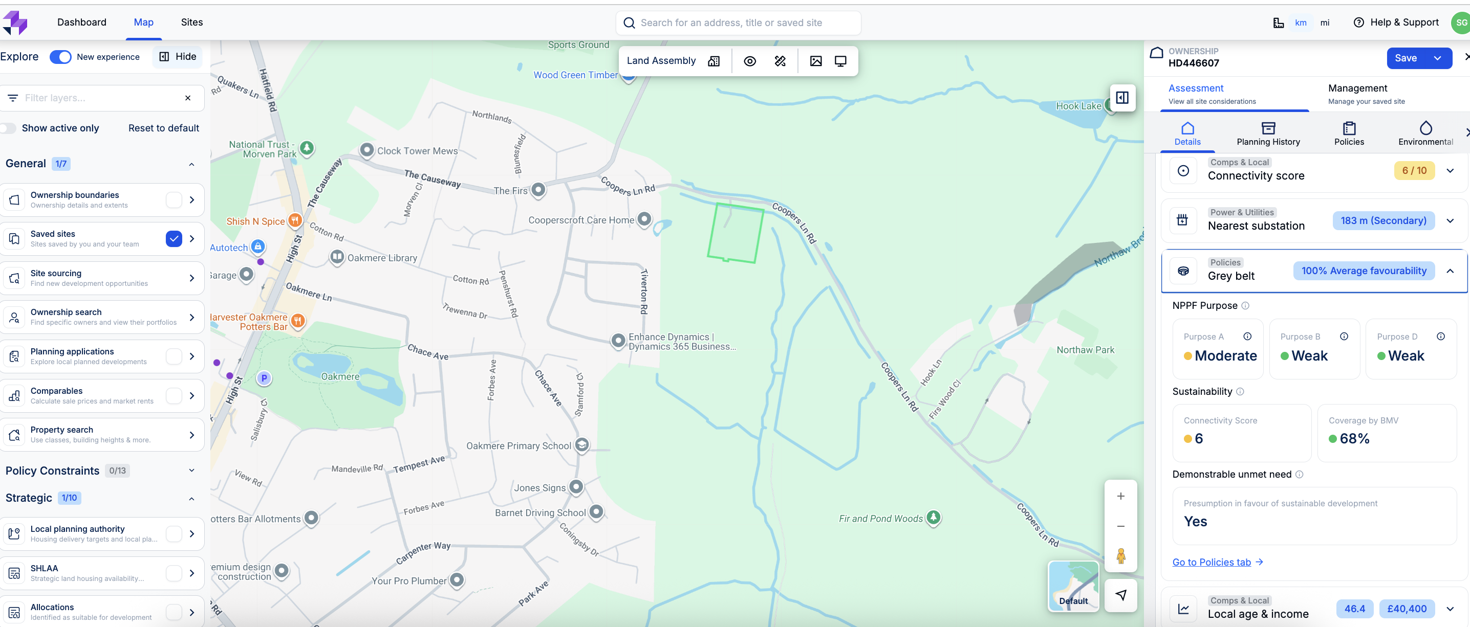
Quick Insights gives you a fast, high-level snapshot of any parcel you click on. It instantly surfaces ownership, planning history, constraints, and policy designations.
It is designed to help you understand whether a site is even worth shortlisting before you invest time in deeper analysis.
Real-life use case: A residential developer scanning the outskirts of Guildford spots a promising parcel. Quick Insights immediately shows that it is in single ownership, has no recent refusals, and sits clear of Footnote 7 constraints. With that quick confidence check, the site moves straight into their ‘worth exploring’ list in under a minute.
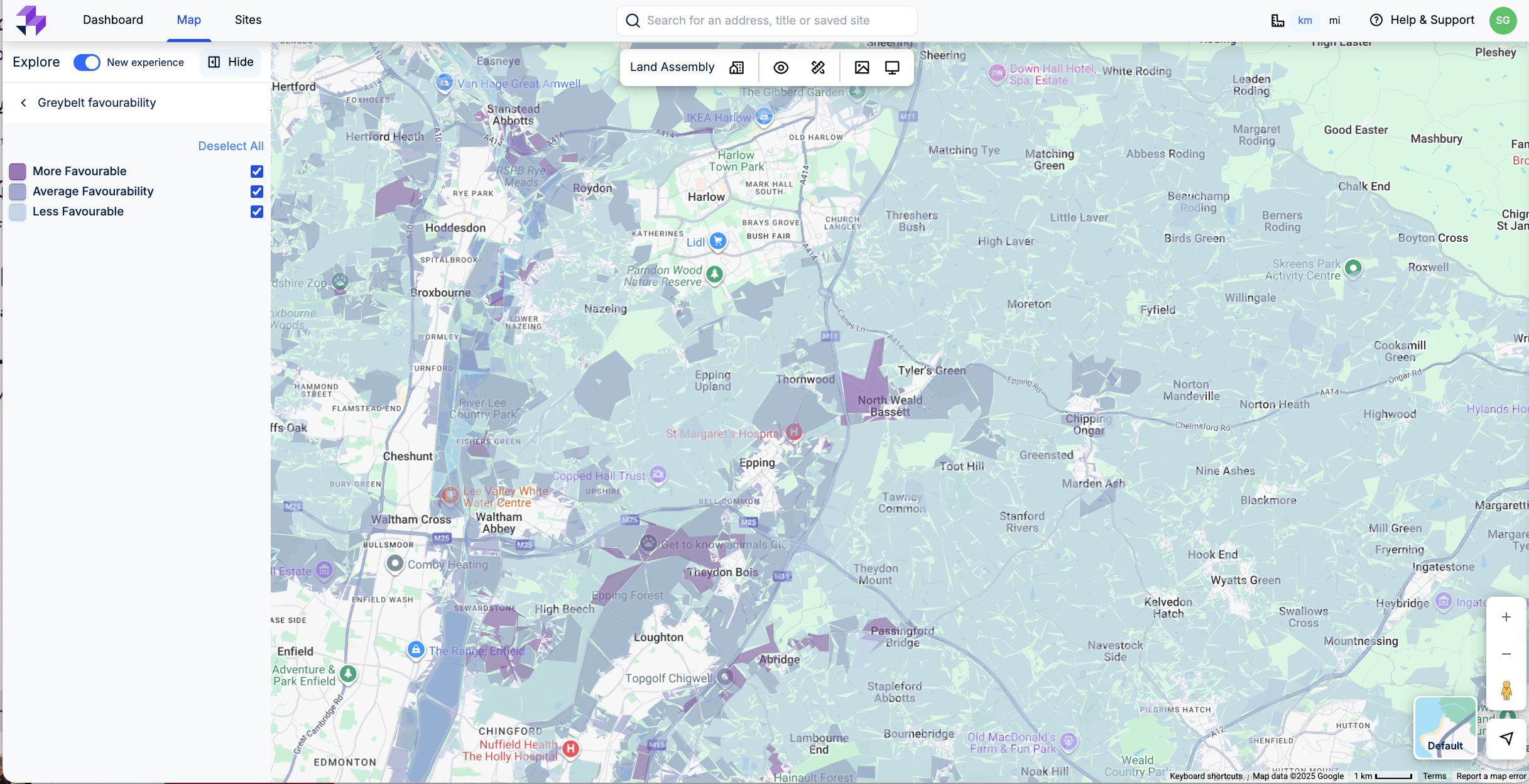
2. Get a Sense of Where to Focus With the Layer Tool
Our Opportunities layer aggregates a wealth of data to highlight areas with high potential for development. When searching for grey belt land, you simply select the grey belt and declassified Green Belt filters in the layer tool.
LandInsight will then highlight relevant parcels on the map and rank them by favourability. This gives you an instant read on where the highest-potential areas sit.
Real-life use case: A care home developer reviewing the West Midlands switches on the grey belt layer and immediately spots clusters of favourable parcels along well-connected corridors. Instead of combing the entire Green Belt edge, they now know exactly where to target their search.
3. Narrow Down Areas with the Site Sourcing Tool
Once you know the areas worth exploring, the Site Sourcing tool lets you define your specific criteria with filters for parcel size, ownership type, and use class filters. Then, combine them with grey belt favourability preferences.
Your results appear on the map and as a downloadable CSV, so you can build out your pipeline or share leads with the wider team instantly.
Real-life use case: An energy developer is looking for one- to three-acre sites near strategic road networks. They enter their criteria, then select High Grey Belt favourability, and generate a shortlist of viable options within seconds. There’s no need for manual filtering or cross-checking multiple datasets.
4. View Site Details for the Full Picture
When a site looks promising, granular details give you the complete context you need. Clicking into a parcel reveals:
- Ownership and title information
- Planning history
- Policy and environmental constraints
- Flood risk and heritage designations
- Local demographics and infrastructure data
This provides the level of detail required to decide whether a site deserves pre-application attention or should be ruled out early on.
Real-life use case: A housing association finds a grey belt parcel that looks suitable. The site details confirm the land sits outside flood zones, is free of heritage constraints, and lies within a local authority (that’s failing its housing delivery test). That's enough evidence for them to move forward with a strong case for pursuing the site.
Take a Strategic Approach to Sourcing and Get Ahead of Grey Belt Opportunities
The landmark PPG grey belt guidance marked a significant shift in Green Belt policy, and offered new opportunities for housing development. However, developers must be prepared to meet stricter requirements around sustainability, constraints, and policy compliance.
LandInsight enables developers to take a data-led approach to identifying viable sites, to ensure they focus their efforts on the most promising opportunities.
As councils assess housing supply and review Green Belt areas, those who act early will be in the strongest position to bring forward successful developments.
*National Planning Policy Framework, GOV.UK
**Green Belt, GOV.UK
A Step-By-Step Process for Finding Grey Belt Sites With LandTech
What does grey belt mean?
Grey belt refers to Green Belt land that makes a limited contribution to three of the Green Belt purposes:
- (a) preventing urban sprawl
- (b) preventing towns from merging
- (d) preserving the setting of historic towns
If land performs weakly against these purposes and is free from Footnote 7 constraints, it may be considered grey belt.
As a result, it could be suitable for certain forms of development, particularly housing, where a demonstrable local need exists.
Where is the grey belt in the UK?
There isn’t a fixed, nationally designated grey belt mapped out in the UK. Grey belt isn’t a formal designation, but rather a status applied to parcels of Green Belt land based on how they perform against the relevant Green Belt purposes.
Because of that, grey belt land can appear anywhere within existing Green Belt boundaries. That said, it is most commonly found:
- On the edges of settlements
- In previously developed or degraded areas
- In land that no longer plays a strong strategic role in separating towns
Each LPA makes its own assessment, so grey belt land is identified site by site, not en masse.
Can you get planning permission on the Green Belt?
You can get planning permission on the Green Belt in specific circumstances. Under paragraph 155 of the NPPF, development in the Green Belt is not considered inappropriate when it meets certain criteria. These include (but are not limited to):
- Limited infilling
- Redevelopment of previously developed land
- Certain forms of infrastructure
- Development on land that performs weakly against the key Green Belt purposes (e.g. grey belt) and meets the additional requirements introduced in the PPG
If development is not classed as appropriate, then it must be justified through ‘very special circumstances,’ which is a significantly higher bar.
What is the golden rules of the green belt?
The PPG update introduced three Golden Rules that apply to major residential development strategies on Grey Belt land. These rules help ensure that development provides meaningful public value in return for releasing Green Belt land.
The Golden Rules require developers to demonstrate the following
- Increased affordable housing: Developments must deliver 15% more affordable housing than the local plan baseline, up to a maximum of 50%.
- Infrastructure improvements: This can include roads, transport, utilities, healthcare facilities, or schools.
- New or improved green spaces: Developments must create or enhance public green spaces, to contribute to local wellbeing and biodiversity.
Learn how LandTech can help you identify, assess, and secure prime grey belt sites faster than ever.
