How to find development sites with the Opportunities layer

Picture of Andrea Duke

Andrea Duke
March 14, 2024
Read time: minute(s)

Accessing accurate and comprehensive information is pivotal - especially when you’re searching for specific opportunity types. And to achieve this, you likely find yourself navigating through the complex landscape of planning regulations, land availability, and market trends to identify viable opportunities. 

This is where LandInsight steps in, transforming the way property developers explore and assess potential development sites. One unique collection of data offered in LandInsight is the Opportunities layer, a view that was created specifically for people who are looking for new opportunities - and looking to do so before the competition. 


What is the Opportunities layer?

The Opportunities layer is a view within LandInsight that aggregates a wealth of data to highlight areas with high potential for development. This layer acts as a digital magnifying glass, bringing into focus the intricate details of land availability, planning policies, and regeneration zones, among other crucial datasets. 

By overlaying this information on a user-friendly map, the Opportunities layer enables developers to quickly identify and evaluate sites that align with their development criteria and strategic goals.

Screenshot 2024-03-06 at 12.37.11 pm

What data is in the Opportunities layer?

The Opportunities layer combines several datasets, each offering unique insights into potential development sites. Below we’ll take a look at these data sets in more depth. 

Land Availability Assessments

Our Land Availability Assessments data set provides the evaluations of land parcels to determine their suitability, availability, and achievability for housing development. This data is divided into a number of assessments taken on by local governments to support local plans.

More specifically in this data set, you’ll see Strategic Housing Land Availability Assessment, which is broken into positive, neutral, and negative classifications and gives you an understanding of what land has been previously promoted for allocation, and which of these sites has support from the LPA . You’ll also have access to parcels noted as a part of the National Brownfield Register.

Read more about where this data is retrieved from and how often it's updated here.


Allocations

This includes designated land parcels in local development plans earmarked for specific types of development, such as residential or commercial use; guiding developers towards sites with predefined development objectives. More specifically, this includes Residential Allocations and Site Allocations including mixed use, commercial, employment, community and uncategorised allocations. Allocations form part of the Local Plan and are derived from both emerging and adopted policy.

Regeneration Zones

Highlighting areas designated for revitalisation, this data helps developers identify opportunities where there might be incentives or support for new projects, aiming to stimulate economic growth and community development. This data set includes Area Action Plans (local plans, both adopted and emerging) and Named Regeneration Areas (again, local plans that are adopted and emerging). 

Local Planning Authority Insights

Our Local Planning Authority Insights is a trove of local planning information, including Community Infrastructure Levy (CIL) information, and the likely ‘presumption in favour’ status of each LPA - derived from information regarding each LPA’s 5-year housing land supply, housing target delivery tests, and adopted and emerging plan dates. This dataset is instrumental in understanding the planning context and potential constraints or facilitators for development.

Declassified Green Belt 

This data set identifies sites that were once within the green belt, but have been reclassified, opening up opportunities for development in areas previously restricted. This information is retrieved from the DLUHC with additional analysis from our LandTech teams, refreshed annually. 

Homes England Land Hub 

This set integrates data from the Homes England Land Hub, which lists public sector land available for development. This information is critical for developers looking for government-owned land with potential for residential or mixed-use projects. This information is pulled directly from the Homes England Land Hub and refreshed weekly, This information is classified as sites that are in the pipeline, on the market or sold subject to contract.

Best practices for maximising the Opportunities layer

By synthesising this data, the Opportunities Layer offers a comprehensive view of the development landscape. Below, we’ll show you how to use this data to your advantage.

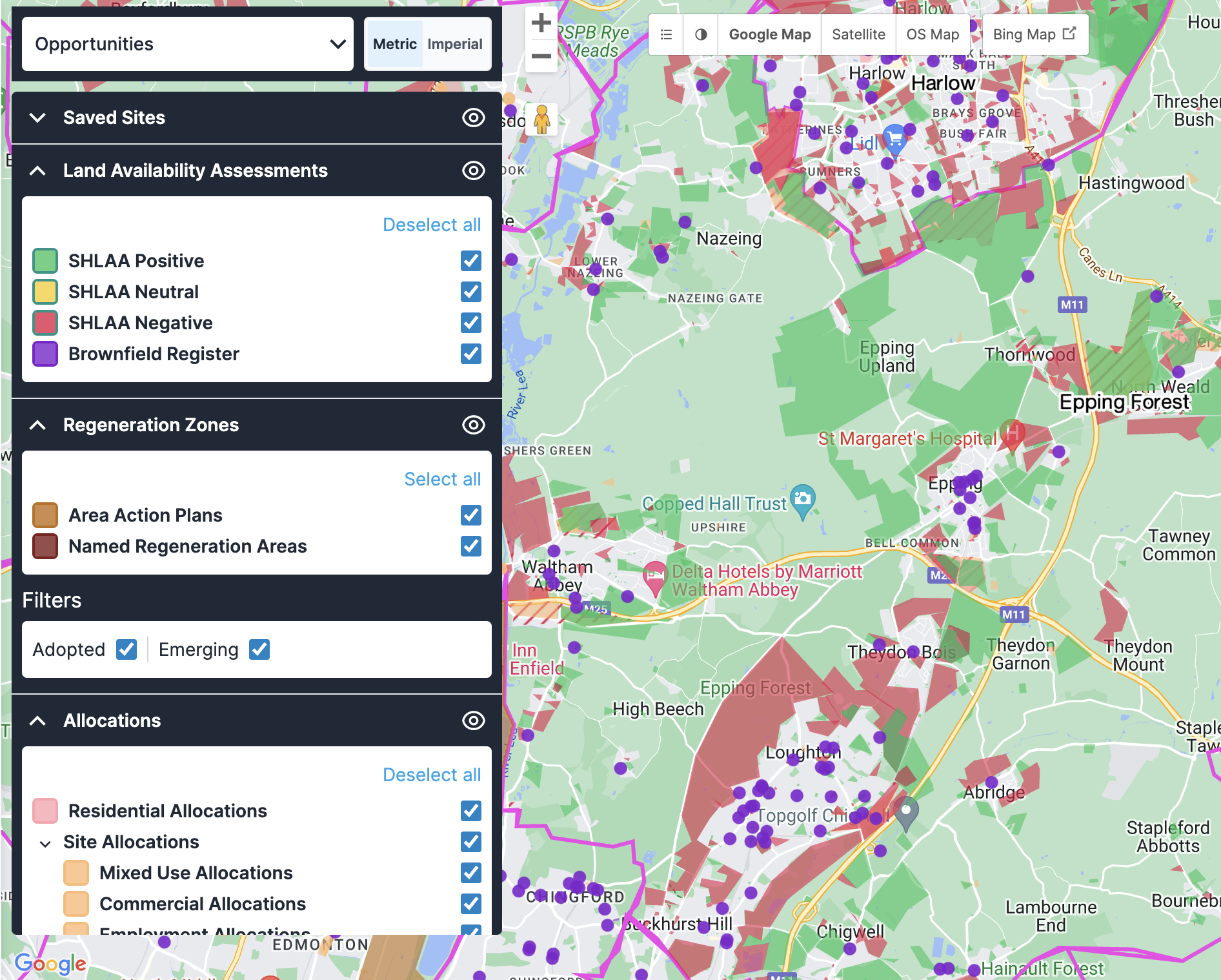
Strategic site identification and acquisition

Property developers can use the Opportunities layer to strategically identify and evaluate land parcels for potential development projects before these opportunities become widely known in the market.

Here’s a few ways to do this: 

  • Filter through the Strategic Housing Land Availability Assessment to find land parcels classified positively, indicating suitability for housing development.
  • By examining Regeneration Zones, you can identify areas with planned economic and community development, where there might be incentives or support for new projects.
  • The Allocations dataset can help you to find land parcels earmarked for specific types of development, ensuring your project aligns with local planning objectives.
  • Declassified Green Belt data can reveal newly available land for development, balancing the need for new homes with environmental considerations.


This approach allows developers to act swiftly on high-potential sites, engage in negotiations with landowners, and navigate through the planning process with a clear understanding of local policies and incentives.


Risk mitigation and planning insight

With access to Local Planning Authority insights and the Homes England Land Hub, developers can gain a deep understanding of planning constraints, housing targets, and available public sector land, helping them to make informed decisions and tailor their development strategies accordingly.

Here’s a few ways to do this: 

  • Utilising Local Planning Authority Insights, you can evaluate the planning context of a potential site, including the 5-year housing land supply and housing target delivery tests, which are crucial for understanding the likelihood of planning approval; and understand the flexibility that may be applied to planning policy via the ‘presumption in favour of sustainable development’.
  • Information on the CIL charges provides insights into potential costs that will apply to new developments.
  • The Homes England Land Hub data set allows developers to identify land that Homes England have been involved with, which can be a strategic move for developers with set special requirements or specific experience. 


By leveraging this data, developers can start to assess the viability of sites, anticipate planning hurdles, and structure their proposals to align with local planning policies and objectives. This proactive approach to site selection and project planning can significantly enhance the feasibility and success rate of development projects.


Ready to get started?

The Opportunities layer is designed to help developers navigate the complex property landscape more effectively, identifying opportunities that might otherwise remain hidden. By using this layer and the best practices mentioned above, you can make more informed decisions and streamline your site sourcing process to identify the sites that hold potential for success. 

What’s even better is that the Opportunities layer is just one of many data set views available within LandInsight that can help you identify the best opportunities for your set criteria.

Want to learn more about the other data layers in LandInsight? Check out our free eBook, The Seven Building Blocks to Success: A Property Developer’s Guide to LandInsight, to take a deeper look at all the data available in LandInsight and how it can help you streamline your site sourcing. 


Download Now