Conducting viability assessments with the Power Infrastructure layer

Picture of Andrea Duke

Andrea Duke
March 19, 2024
Read time: minute(s)

In the rapidly evolving landscape of renewable energy, finding suitable parcels of land for solar farms, wind farms, and battery storage projects presents a tough challenge. 

Developers face the task of identifying large enough plots with sufficient grid capacity, coupled with the complexities of understanding land ownership. Compounding these challenges is the fragmented nature of relevant data, making it difficult to access accurate and comprehensive information. 

Recognising these hurdles, LandInsight has dedicated an entire layer to not only help overcome the challenges power developers face, but also to provide crucial power infrastructure information to residential and commercial developers as well. The Power Infrastructure layer is designed to centralise and simplify access to critical data for power development across England, Wales, and Scotland.


What is the Power Infrastructure layer?

The Power Infrastructure layer is a bespoke solution tailored for developers and power developers, offering a streamlined and efficient way to access pivotal information critical to the success of their projects. 

This layer provides users with an invaluable resource for scouting potential development sites. And by centralising essential DNO map data like substations, tower and cable information and significant constraints, the Power Infrastructure layer empowers developers to make informed decisions, optimise their project planning, and navigate the complexities of finding the perfect site with ease and confidence.

landinsight power infrastructure layer

What data is in the Power Infrastructure layer?

Now that we have the basics of the Power Infrastructure layer covered, let’s take a deeper look at the data available in this layer, where the data comes from, and how often it's updated.

Substation information

The data set aggregates detailed substation data from key providers, including Electricity North West, Northern Powergrid, SP Energy Networks, UK Power Networks, SSE, and Western Power Distribution (now part of National Grid). This data, vital for assessing grid connectivity and capacity, is refreshed daily, ensuring developers have access to the most current information available.

Tower and cable information

Comprehensive details about towers and cables are crucial for understanding the infrastructure's layout and capacity. This information is sourced from UK Power Networks, Western Power Distribution, and Electricity North West, with quarterly updates. 


For areas outside the direct coverage of Distribution Network Operators (DNOs), LandInsight incorporates data from OpenStreetMap to provide complete UK coverage, with annual refreshes, ensuring developers have a clear overview of the power landscape.

Energy projects

This dataset provides users with information on existing and proposed renewable energy projects to assess the local area and identify competition or opportunities. This data is retrieved from the Renewables Energy Planning Database (REPD). To ensure users can see the full extent of these projects, this data is enhanced with polygons from our planning database where possible (around 2,500 of them). 

Significant constraints and Agricultural Land Classification

Understanding potential site constraints and the classification of agricultural land (ALC) is essential for project viability and strategic planning. The Power Infrastructure layer includes this data, helping users to identify and mitigate risks early in the project lifecycle.


Best practices for maximising the Power Infrastructure layer

Overlaying all of this data into an easily accessible map view, developers can source sites, conduct due diligence, and mitigate risks all in one go. Below, we’ll cover two ways to make the most of this view within LandInsight. 

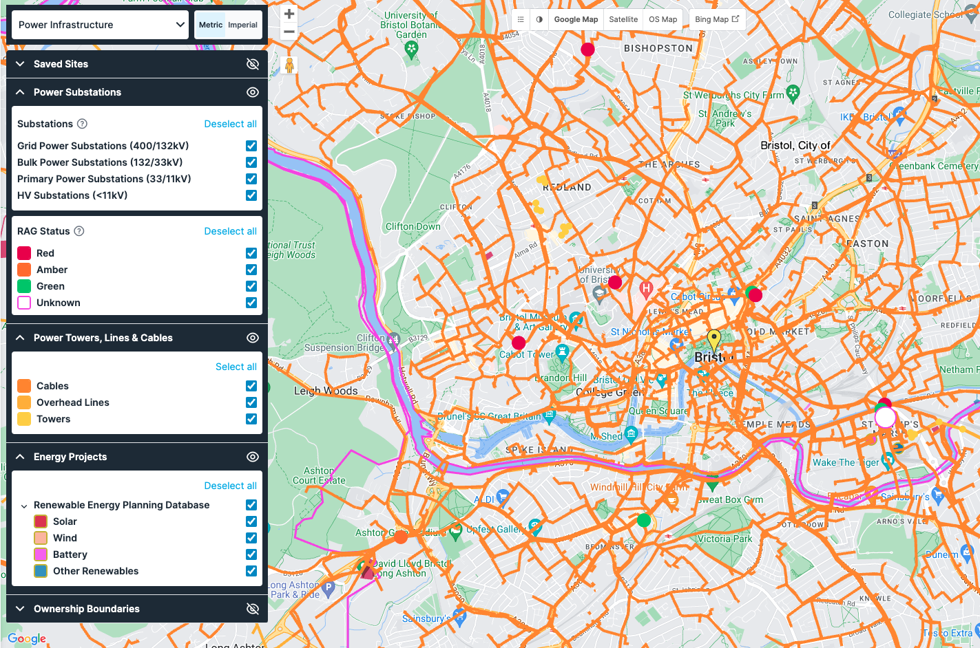
Filter to find sites based on your requirements

While understanding where substations or over lines are located is important for any development, to find the perfect site you may have additional criteria you need to filter for as well. In the Power Infrastructure layer, you can filter for and overlay all of the data mentioned above, as well ownership boundaries and types and parcel sizes.

For power developers, the ability to search specific requirements can not only help with informed decision making and optimised project planning, but it can also help you to understand the competitive landscape in the renewable energy development sector. 

For those working in residential or commercial development, once you’ve found a potential site it’s important to use this search and filter functionality to review both the distance from the grid and the capacity of the nearest substation. Evaluating your site’s proximity to a substation will allow you to consider and potentially reduce any additional costs of getting connected to the grid.

Managing your sites effectively

With the sites pipeline you can set custom stages for each site, so you can keep track of all potential sites, awaiting response, positive/ negative response, contracts sent – whatever you need. And if you need to collaborate with colleagues you can share the sites pipeline so everyone gets a clear visual representation of the stage each option is at.

Here’s our top 10 tips on getting the most out of your sites pipeline.


Start making more informed decisions

By centralising disparate data into a cohesive and user-friendly platform, our goal is to not only address the challenges faced by power developers, but also to pave the way for a more sustainable and efficient future in energy development. 

The Power Infrastructure layer is just one of many views within LandInsight that can help streamline site sourcing and assessment. 

Check out our free eBook, The Seven Building Blocks to Success: A Property Developer’s Guide to LandInsight, to take a deeper look at all the data available in LandInsight and how it can help you streamline your site sourcing. 


Download Now