
At LandTech, providing you with high quality (and easy to understand) data is our top priority. We want to make your lives easier – and a big part of that is making sure that you have accurate and up-to-date data at your fingertips.
From ownership to planning policies and even power infrastructure data, LandInsight provides a variety of datasets and information. You may be wondering - “where does LandTech get its data from and how often is it refreshed?” It’s a great question, and one we’re proud to answer.
Our team of over 60 data experts, engineers and product managers work to ensure we’re not only providing you with the most relevant and reliable datasets to keep you ahead of the competition, but the most up-to-date as well. Below, we’ll break down each dataset available, its source and how often it is updated.
Maps and Satellite Imagery
LandInsight’s datasets are overlaid in two ways: Google Maps (road map and satellite) and OS Maps. Both types of map imagery are integrated directly from the source and are refreshed as often as the source updates, which can vary. However, you can feel assured that as soon as Google or Ordnance Survey update their services, so too is the map imagery inside of LandInsight.
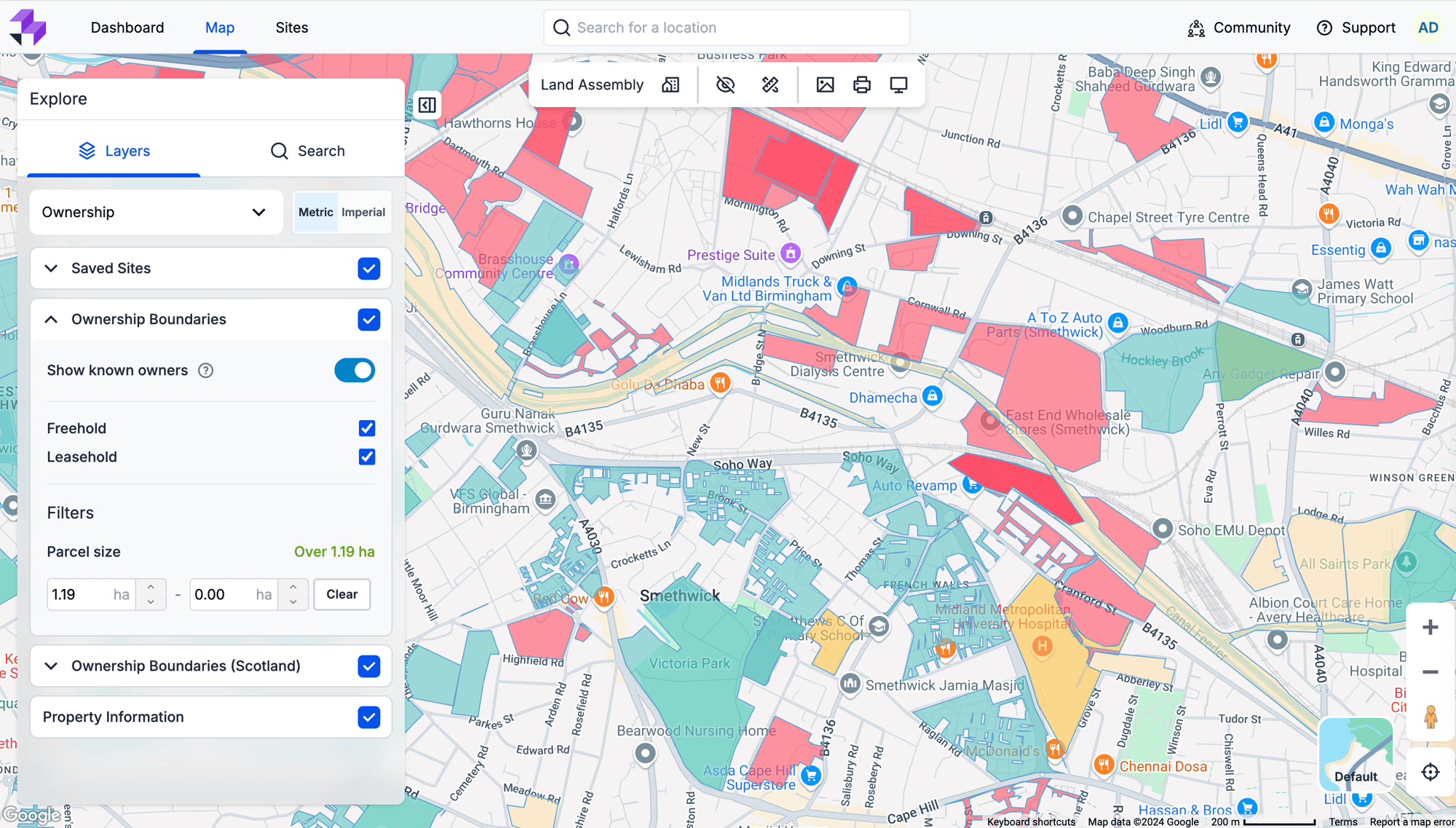
Ownership View
Our ownership data is supported digitally through the Land Registry, which is currently available in England and Wales. Therefore, within LandInsight, you’ll have a full view of these two countries. However, it is important to note that full Registers of Scotland data is not available digitally, so we are unable to offer this in our coverage.
Below is a breakdown of the datasets you can expect to see in LandInsight in regards to ownership, and how often they are updated:
- Parcels: HM Land Registry, refreshed every month on the 6th.
- Ownership Information: HM Land Registry and Companies House, also updated monthly.
- Addresses: OS AddressBase Plus, refreshed every 4-6 weeks.
Planning Applications View
The data in our Planning Applications layer currently covers England, Wales, and Scotland.
- Planning application information: local planning authorities (LPAs), including planning application details and boundaries (where possible). This is refreshed every 24 hours.
- Planning application boundaries: we source these directly from the planning authorities.
- Planning appeals: Planning Inspectorate Appeals Database, updated every 3 months.
- Significant constraints: See Planning Policy View
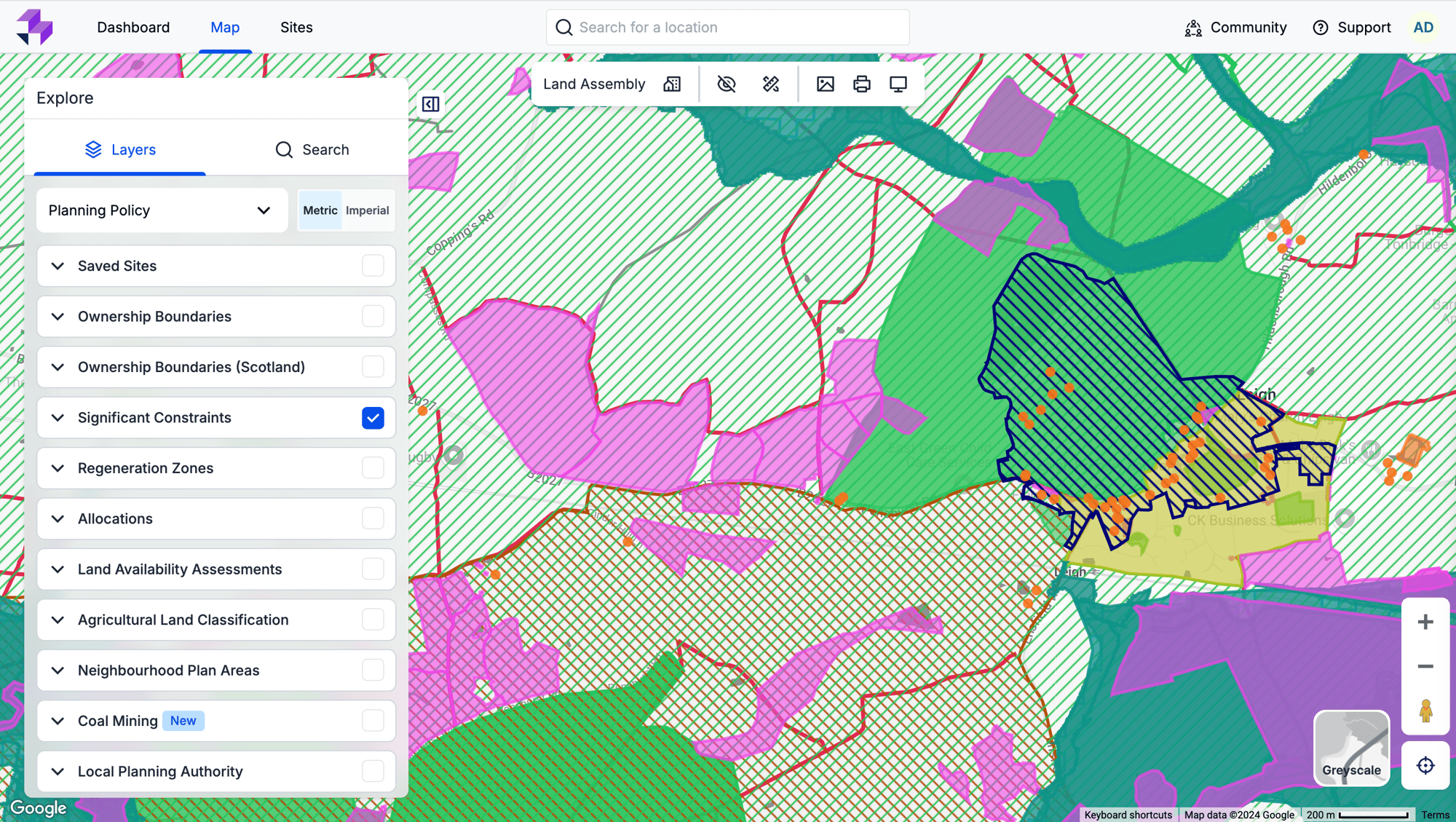
Planning Policy View
Our Planning Policy data is available nationally for England, Scotland and Wales (but local data is currently only available for England and Wales) and includes a plethora of information to better understand opportunities in your chosen area.
At a national level we have information on flood zones, listed buildings, Sites of Special Scientific Interest (SSSIs), Areas of Outstanding Natural Beauty (AONBs), Special Areas of Conservation (SACs), Special Protection Areas (SPAs), and Ramsar sites. We also have information about areas affected by the current Nutrient Neutrality requirements set by Natural England.
At a local level we have adopted local planning policy including Green Belt areas, settlement boundaries, housing allocations, conservation areas, Sites of local importance for nature conservation (LINC), Site of Borough importance for nature conservation (BINC), Area of Metropolitan importance for nature conservation, and Local Nature Reserves.
We also hold relevant local evidence (which supports a local plan but is not policy itself) including Strategic Land Availability Assessments (SHLAAs (for housing land) and SHELAAs (for housing and employment land)) as these documents can give a great insight into what land is being promoted for development in a certain area, and how the council viewed the suitability of each site at the time it was last assessed.
Adopted Local and National Policy are constantly monitored for changes with any alterations or modifications being digitised and adopted into LandInsight generally within a month. Each dataset has a date associated with it, this indicates when the layer was last updated. By comparing this date with the date of policy change you should be able to see if any changes to adopted policy have been included or not.
For emerging policy, including land availability assessments, the frequency of refresh is varied. Our data team monitors any consultation and this information is directly applied within the feature’s layer in LandInsight – and we check monthly for any updates that need to be added. As a general rule, we focus on emerging policy that has reached the Regulation 19 stage (i.e. it’s a final draft of the policy that is ready for submission to the Planning Inspectorate).
Significant Constraints
Our significant constraints data includes:
- Flood zone: Environment Agency Flood Zones 2 and 3, Natural Resources Wales Flood Zones 2 and 3
- Flood risk: Environment Agency Risk of Flooding from Rivers and the Sea, Scottish Environment Protection Agency (SEPA) Risk of Flooding from Rivers and the Sea, Natural Resources Wales Risk of Flooding from Rivers and the Sea
- Conservation Areas: Historic England/Local Authorities/Historic Environment Scotland/Cadw
- Protected Area: these cover the following:
- SSSIs
- Sites of local importance for nature conservation (LINC)
- Site of Borough importance for nature conservation (BINC)
- Area of Metropolitan importance for nature conservation
- Local Nature Reserves
- Wildlife corridors
- National Landscapes (formerly AONB)
- National Nature Reserves
- Ramsar sites
- Special Areas of Conservation
- Special Protected Areas
- Biosphere Reserves
- Ancient Woodland
- Common Land
Natural England/Local Authorities/Natural Resources Wales/Scottish Natural Heritage
- Settlement boundaries and other policy designations: From Adopted Local Plan for each local authority, and Emerging Local Plan (if available)
- Green Belt: Ministry of Housing, Communities and Local Government (MHCLG), Improvement Service (Scotland), Local Authorities (Wales)
- Nutrient Neutrality: Natural England, Natural Resources Wales, Local Planning Authorities
- Water Neutrality: Environment Agency, Local Planning Authorities
- Heritage Land/Listed buildings/Historic Battlefields - Historic England, Cadw, Historic Environment Scotland
- Rights of way: Local Planning Authorities and other public sources
- Tree Preservation Order: HMLR LLC INSPIRE data, planning.data.gov.uk, local planning authorities, Scottish Government
- Metropolitan Open Land: London Datastore, Local Planning Authorities
Regeneration Zones
Our regeneration zones data includes:
- Area Action Plans: local plans, both adopted and emerging
- Named Regeneration Areas: local plans, both adopted and emerging
Allocations
Our allocations data includes:
- Residential Allocations: local plans (adopted and emerging)
- Site Allocations: local plans (adopted and emerging)
Land Availability Assessments
Land availability assessments data includes the following:
- SHLAA: local authorities
- Brownfield Register: Point data: planning.data.gov.uk (sourced and collated from individual local authorities, cleaned by LandTech) and are required to be updated annually
- Polygon data: London Datastore, individual local authorities
Agricultural Land Classification
Natural England and Natural Resources Wales maintain a classification of how valuable different bits of agricultural land are. The aim of this process is to safeguard the ‘best and most versatile’ (BMV) agricultural land from development. Knowing if your site is classified as BMV will be one of the constraints that you should factor into a site feasibility assessment. This dataset is updated periodically and we will update our record of this accordingly.
Neighbourhood Plan Areas
Introduced as part of the Localism Act 2011, a neighbourhood plan is a document that sets out planning policies for a local area and can protect local green spaces, encourage better-designed places and bring forward housing that genuinely meets local needs. If designated, a neighbourhood plan comes into force as part of the statutory development plan. Applications for planning permission must be determined in accordance with the development plan unless material considerations indicate otherwise. There are nearly 3,000 neighbourhood planning areas in England, and 1,146 have reached the stage of formally adopting a plan.
Data sourced from Department for Levelling Up, Homes and Communities (DLUHC), Office for National Statistics, and additional processing and analysis by LandTech. Refreshed quarterly.
Local Planning Authority
- Community Infrastructure Levy (CIL) - local authorities, refreshed annually
We also include key information about the status of local planning within each local planning authority.
The NPPF outlines, in paragraph 11, that there should be a ‘presumption in favour of sustainable development’ when making decisions on planning applications. The NPPF sets out (paragraph 11c) that where there is an up-to-date development plan in place, and where the applications accords with that plan, applications should be approved without delay.
It also states (paragraph 11d) situations where the local development plan can be effectively set aside unless the land is itself protected by the NPPF (e.g. it’s in Green Belt). These situations include:
- Where the local plan is out of date (i.e. more than five years old); or
- Where the council has achieved delivery of less than 75% of its need in the Housing Delivery Test (or government housing targets); or
- Where the council is unable to demonstrate five years of housing land supply.
If a council finds itself in this unfortunate situation, they only have one way to refuse a planning application that does not affect one of the designations that are protected by the NPPF itself (including green belt). That is if they decide that the adverse effects of an approval would ‘significantly and demonstrably outweigh the benefits’.
We track information on the age of planning policy (e.g. is the local plan over five years old and is there an emerging plan on course for adoption?) and is updated in LandInsight monthly. Again, each layer has a date associated with it, this indicates when the layer was last updated. By comparing this date with the date of policy change you should be able to see if any changes to adopted policy have been included or not.
Housing Delivery Test is a national dataset that is published nationally on an annual basis. The most recently published data on Housing Delivery is from 2021, as soon as an updated set of data is released we will be on the case.
- Presumption in Favour (England only) - sourced from local authorities and Department for Levelling Up, Housing and Communities (DLUHC).Coal mining
Coal Mining
For many areas across the UK, mining activities ceased decades ago, but its impact is much a present-day issue. For developers, understanding the impact of historic mining data on potential development sites isn’t just about safety, it’s about avoiding costly surprises that could stop the project entirely.
Our Coal Mining data layer is designed to help navigate the complexities of building areas impacted by historical coal mining to help identify potential risks before you get started. Below, we’ve provided the data available in the Coal Mining data layer within the Planning Policy view.
- Coal mining reporting areas: sourced from the Mining Remediation Authority (formerly the Coal Authority), updated quarterly.
- Development high risk areas: sourced from the Mining Remediation Authority, updated quarterly.
- Mine entries: sourced from the Mining Remediation Authority, updated quarterly.
- Surface mining: sourced from the Mining Remediation Authority, updated quarterly.
- Past shallow coal mining workings: sourced from the Mining Remediation Authority, updated quarterly.
- Probably shallow coal mining workings: sourced from the Mining Remediation Authority, updated quarterly.
Opportunities View
Land Availability Assessments, Regeneration Zones, Allocations and LPA insights have been added to this layer from the Planning Policy View specifically for clients that are looking for new opportunities.
Additional Opportunities
- Grey Belt and Declassified Green Belt - Department for Levelling Up, Housing and Communities (DLUHC) with additional processing and analysis by LandTech. Refreshed annually
- Homes England Land Hub - Pipeline, On Market and Sold STC are sourced directly from Homes England and refreshed weekly
Planning Application information has also been added to this layer which has the exact same process of refresh as the Planning Application View.
Power Infrastructure View
Finding large enough parcels of land with access to grid capacity, and understanding the ownerships of those parcels, are challenges we’ve seen power developers having to contend with increasingly frequently - especially when looking to develop solar-farm, wind-farm, and battery storage projects.
And with data being disparate, it can be hard to get a handle on the most relevant and accurate information. To help with this, we’ve created a Power Infrastructure view within LandInsight to centralise the data. This data is available for England, Wales and Scotland.
In our Power Infrastructure view, we provide:
- Substation information: retrieved from Electricity North West, Northern Powergrid, SP Energy Networks, UK Power Networks, SSE, Western Power Distribution (now part of National Grid). This information is refreshed daily
- Renewable Energy Database: sourced from Department for Energy Security and Net Zero, and it is updated quarterly. Tracks the progress of all renewable energy projects over 150kW through the planning system.
- Tower and Cable information: retrieved from UK Power Networks, Western Power Distribution and Electricity North West and refreshed quarterly. All other areas where data is not available directly from the Distribution Network Operator (DNO) are covered by extracts from OpenStreetMap to give full UK coverage. Information from OpenStreetMap is refreshed annually.
- Significant Constraints and ALC data: See Planning Policy View.
Property Information View
LandInsight’s Property Information view provides an overlay of information including Use Class, property status, type of property (i.e., detached, semi-detached, terrace, etc., building dimensions, height of buildings nearby, listed building nearby, and whether the property falls within constraints such as flood risk or protected land (see above Planning Policy section for more information on constraints).
This overview is helpful for understanding not only the property you may be interested in, but those nearby, giving you a clear picture of any challenges or opportunities in the vicinity.
In the Property Information view we provide:
- Use Class, type of property and status: retrieved from OS AddressBase Plus, refreshed every 4-6 weeks
- Building dimensions: pulled from OS Master Map
- Listed building: retrieved from Historic England, Historic Environment Scotland and Cadw (in Wales)
Comparables View
With our recent partnership with Hometrack, powered by Zoopla, our Comparables view is now more robust than ever. In this layer, users can filter by five different price modes, by price type, and date sold. The five price mode filters include: Sold prices, market value, Hometrack asking rental, Hometrack estimated rental, and Hometrack valuation.
Using this data and filtering, property professionals can identify potential development opportunities, which can then be accurately valued, as well as view regularly updated achieved prices to make better predictions towards their own ROI. Also available is our comparables calculator, which now includes the Hometrack data listed above.
Below is a complete list of all the information available within the Comparables view within LandInsight:
- Sale prices: retrieved from HM Land Registry - Price Paid, refreshed monthly
- Market values: HM Land Registry - UK House Price Index, refreshed weekly
- £/sq ft values: Floor area is determined from the latest Energy Performance Certificate (EPC) and is refreshed monthly
- New build data: HM Land Registry - Price Paid, refreshed monthly
- Number of bedrooms: Number of habitable rooms from latest EPC, refreshed monthly
- Floor area: retrieved from EPC and is refreshed monthly
All Hometrack data is sourced directly from Hometrack, powered by Zoopla. They use a variety of sources, including quantity surveyors’ measurements to keep information as accurate as possible. If you’re interested in having access to this data, please contact your Account Executive, Account Manager, or Customer Success Manager for more details.
Biodiversity Net Gain
Developers must now evaluate the pre-development biodiversity value of a site and then show how their project will lead to a net gain in biodiversity.
The policy, introduced in early 2024, includes provisions that penalise any attempts to influence the assessment outcome, such as pre-clearing or damaging the site's biodiversity. If biodiversity cannot be demonstrated on the site, biodiversity offset sites must be established and maintained for at least 30 years to show an overall BNG uplift.
To help our users with this change, we’ve added the Biodiversity Net Gain layer. The aim of this new layer is to provide property developers with two main things:
- Indications of high value or irreplaceable habitats at a site which may result in a development being unviable, particularly complex, or requiring bespoke negotiation and compensation.
- Provide information to assist clients in determining more suitable areas to search for offsite BNG mitigation.
Below is the complete set of information available in this layer:
- National Character Areas: retrieved from Natural England, updated quarterly
- OS Open Rivers: retrieved from OS, updated quarterly
- Water Body Catchments: retrieved from Environment Agency, updated quarterly
- Operational Catchments: retrieved from Environment Agency, updated quarterly
- Irreplaceable Habitats (Ancient Tree Inventory): from the Woodland trust, updated monthly
- Irreplaceable Habitats (Spartina Saltmarsh Sward): retrieved from Environment Agency, updated annually
- Irreplaceable Habitats (all others): retrieved from Natural England, updated monthly
- Open Mosaic Habitats: retrieved from Natural England, updated monthly
- Priority Habitat Inventory: retrieved from Natural England, updated monthly
- Other Protected Habitats (National Nature Reserves, Ramsar site, etc.): retrieved from Natural England, updated monthly
- Other Protected Habitats (LINC, BINC, etc.): retrieved from local planning authority, updated periodically, when information is available
Demographics and Amenities
Added together in LandInsight, this layer provides users with the ability to review a wide array of demographics information and local amenities in one place to help assess an area or single site’s viability.
Below is the information available from our Amenities data:
- Education: retrieved from Edubase, available in England and updated annually at the start of the school year
- Public transport: retrieved from the National Public Transport Access Nodes (NaPTAN) from the Department of Transport, available across Great Britain and updated monthly
- Healthcare: retrieved from the NHS, available in England and Wales and updated annually
- Retail: retrieved from Geolytix, covering branded grocery retail outlets. Available in Great Britain and updated annually
And here is the information available on Demographics:
- Age 5 year bandings: retrieved from ONS Census 2021, available in England and Wales, updated when available
- Population projections: retrieved from ONS, available in England and Wales
- Income: retrieved from ONS, available in England and Wales, updated when available
- Housing Affordability: retrieved from ONS, available in England and Wales, updated when available
- Indices of Multiple Deprivation (IMD): retrieved from MHCLG/OSCI/Deprivation.org, available in England and Wales, next update due in 2025
- Employment: retrieved from ONS Census 2021, available in England and Wales, updated when available
- Occupation: retrieved from ONS Census 2021, available in England and Wales, updated when available
- Occupancy rate: retrieved from ONS Census 2021, available in England and Wales, updated when available
- Population density: retrieved from ONS Census 2021, available in England and Wales, updated when available
- Dwelling density: retrieved from OS, available in England and Wales, updated annually
- Dwelling type: retrieved from ONS Census 2021, available in England and Wales, updated when available
- Property tenure: retrieved from ONS Census 2021, available in England and Wales, updated when available
- Dwelling age: retrieved from CDRC/Valuation Office Agency/ONS, available in England and Wales, updated when available
What if something I need is missing?
All of this powerful data can help you to find and assess new opportunities in just a few clicks.
However, please let us know if there’s anything else you may need to make your site sourcing even more efficient, or if there’s anything missing. This may include refresh times, or certain datasets that haven’t been included in this article. If that’s the case, please complete this survey and we will do our best to accommodate your needs.