This blog was updated June 2026
If you've spent any time in the world of residential development, you'll know that the planning system runs on acronyms. NPPF. LPA. CIL. HDT. It's a language all of its own - and SHLAA is one of the more important words in that vocabulary.
Get to grips with it, and SHLAA becomes one of the most powerful tools in your site sourcing armoury. Ignore it, and you're working harder than you need to.
Here's everything you need to know: what SHLAA is, why it matters more than ever right now, and how to use it without losing half your week to thousand-page PDFs.
Key Insights
- SHLAA (Strategic Housing Land Availability Assessment) is a dataset produced by every Local Planning Authority in England, identifying land with potential for residential development
- It's one of the most efficient ways to find development-ready sites - and to rule out the ones that aren't worth your time
- The December 2024 NPPF changes have made SHLAA more relevant than ever, with over 60% of LPAs now unable to demonstrate a five-year housing land supply
- SHLAA data is publicly available but notoriously difficult to access - documents can run to over a thousand pages, with no consistent format across councils
- LandInsight brings SHLAA and other Land Availability Assessment data into one place, colour-coded on a map, so you can find and assess sites in minutes rather than days
What is SHLAA?
Strategic Housing Land Availability Assessment - SHLAA - is the process each Local Planning Authority (LPA) in England uses to identify sites with potential for residential development.
It's a requirement of the National Planning Policy Framework (NPPF), and every LPA must carry one out. The purpose is to map a future pipeline of land that is suitable, available, and achievable for housing development over the plan period, giving both planners and developers a picture of where homes could realistically be built, and when.
In practice, SHLAA takes into account nearby constraints, estimated development timescales, and dwelling capacity. National guidance sets a minimum site threshold of five dwellings, so you won't find garden extensions in here - these are genuine development opportunities.
A key output of the process is a housing trajectory: an indicative timeline of future supply broken down by deliverable sites (years one to five) and developable sites or broad locations for growth (years six to ten, and beyond).
The Acronym Family
SHLAA sits under the broader Land Availability Assessment umbrella. Depending on the local authority, you might also come across:
- HELAA - Housing and Economic Land Availability Assessment
- SHELAA - Strategic Housing and Employment Land Availability Assessment
- SLAA - Strategic Land Availability Assessment
- HLAA - Housing Land Availability Assessment
- ELAA - Employment Land Availability Assessment
Each covers a slightly different slice of the market. For residential developers, SHLAA is usually your starting point - but it's worth knowing what the others are, because they're not always clearly signposted.
Why SHLAA Matters More Than Ever
SHLAA has always been a useful tool. But right now, in 2026, it's more relevant than it's ever been - and here's why.
The government's revised NPPF, published in December 2024, made sweeping changes to the planning landscape. Housing targets are now mandatory (not advisory), a new standard method for calculating Local Housing Need has significantly increased requirements across much of England, and the five-year land supply requirement - which had been watered down in the previous version - has been fully reinstated.
The result? Many local authorities are under serious pressure. Between May 2024 and May 2025, the proportion of local authorities without a proven five-year land supply rose from 33% to 61%. That's a significant shift - and it has real implications for developers.
Where LPAs fail to demonstrate a five-year supply, the presumption in favour of sustainable development kicks in, and the refusal bar rises: decision-makers now need strong reasons - not merely clear ones - to say no.
In plain terms: knowing which local authorities are struggling with their housing targets, and which sites they've already identified as development-ready, gives you a meaningful competitive edge. That's exactly the kind of intelligence SHLAA provides.

What Can You Actually Do With SHLAA?
Cut out the dead ends
Sites in SHLAA have already been assessed against planning criteria. You're not starting from scratch - you're working from a pre-filtered list of land that an LPA has determined has development potential. That's a significant shortcut.
You can quickly rule out sites with constraints that don't work for you and focus your energy where it's most likely to pay off.
Find the opportunities others miss
Sites with constraints aren't automatically off the table. In fact, constrained sites can be some of the most interesting opportunities - there's less competition, and if you have the planning knowledge to navigate the complexity, there are often better deals to be made.
SHLAA amber and red-rated sites can be a hunting ground for developers who know what they're doing.
Get ahead of the market
SHLAA documents are forward-looking. They give you a picture of where an LPA expects development to come forward over the next 10 to 15+ years. For strategic land plays, or for anyone trying to understand the trajectory of a particular area, that's genuinely valuable intelligence that isn't easily available anywhere else.
Understand the planning context of an area
Even if you're not pursuing a SHLAA site specifically, the assessment documents tell you a lot about how an LPA thinks. Their five-year land supply position, how they're responding to housing targets, which areas they see as priorities for growth - all of that context shapes the environment you're operating in.
The Problem With SHLAA (And It's a Big One)
Here's the catch: SHLAA data is genuinely useful, but accessing it in any meaningful way has traditionally been a serious time investment.
There's no single national dataset. Every LPA publishes its own assessment, in its own format, with its own level of detail. Presentation varies enormously between councils. Some documents run to more than a thousand pages. Cross-referencing multiple PDFs to build a complete picture of even one site is the kind of task that swallows entire days.
Multiply that across several local authority areas - which is standard for any developer working across a region - and you've got a bottleneck that genuinely slows your pipeline.
There's also a consistency problem. Some SHLAAs are updated annually and well-maintained. Others are years out of date. The level of site detail provided varies from comprehensive to almost nothing. It takes real time and effort to sort through it all and extract anything actionable.
Here’s How LandInsight Solves It
Within LandInsight, you can now see SHLAA and other land availability assessment data (for the LPAs we currently have coverage for) all in one place. It’s been handily added as a new map layer under Planning Policy.
We’ve colour-coded SHLAA sites for an instant insight into their development potential:
- 🟢 Green - positive
- 🟡 Amber - neutral
- 🔴 Red - negative
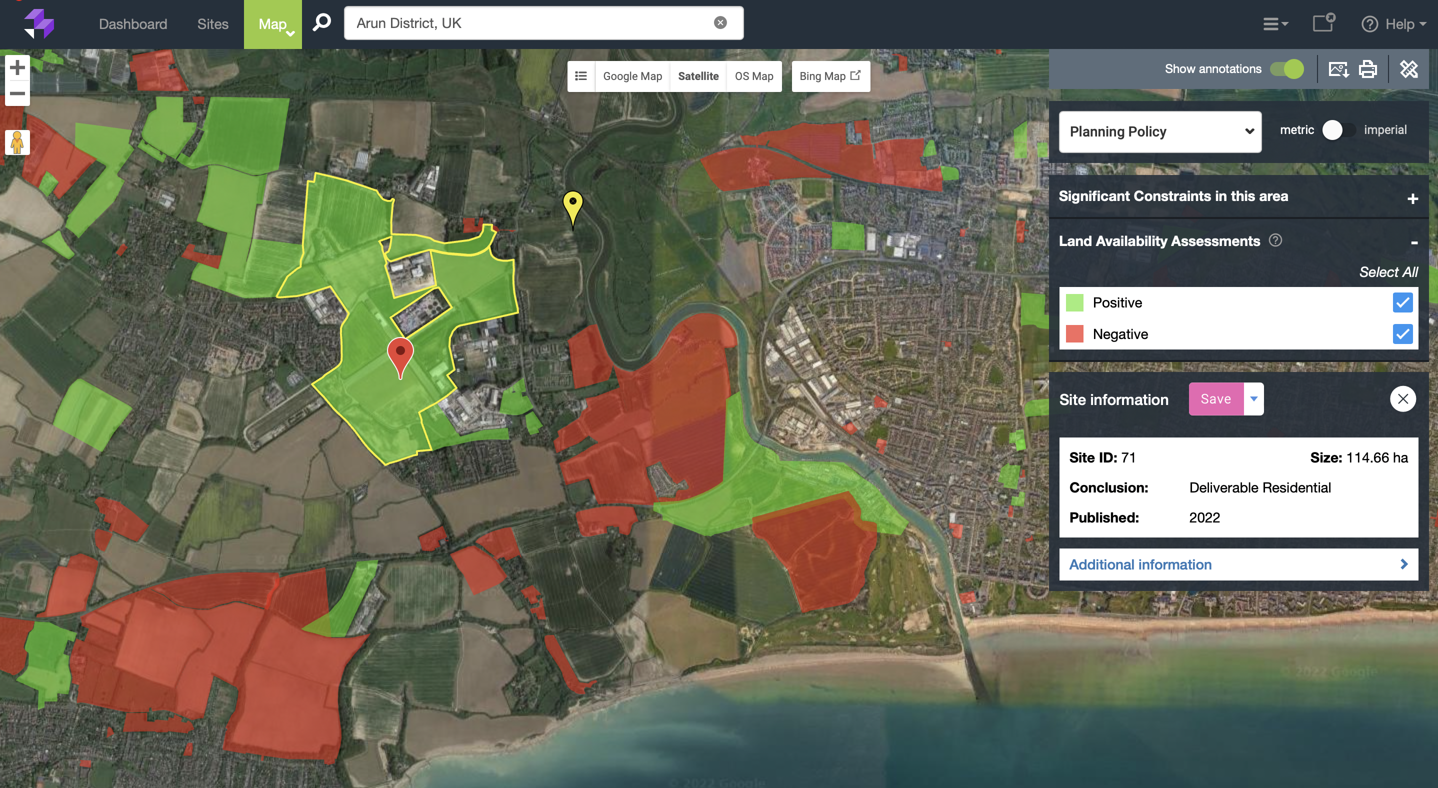
You can toggle site types on and off depending on what you're looking for - positive only, or amber sites you want to investigate further. Click into any site for high-level details. Link directly through to the original LPA documentation without leaving the platform.
What used to take hours now takes minutes.
Paired with planning policy intelligence
SHLAA doesn't exist in a vacuum - its value increases when you can see it alongside the broader planning picture. In LandInsight, you can cross-reference SHLAA data with an LPA's five-year housing supply position, Housing Delivery Test results, local plan age, and CIL data, all in one place. That combination tells you not just where the sites are, but how motivated a local authority is to see them built out.
In the current planning environment, that context is everything.
A quick word on the acronym cousins
Depending on the LPA and the type of development you're pursuing, you may find yourself looking at HELAA, SHELAA, or SLAA documents rather than a traditional SHLAA. LandInsight's Land Availability Assessment layer brings these together, so you're not having to track down and cross-reference different document types across different council websites.
In Summary
SHLAA has always been one of the most useful datasets available to residential developers. But in the context of the December 2024 NPPF changes - mandatory housing targets, a reinstated five-year supply requirement, and a planning system under significant pressure - it's become even more valuable.
Knowing where the opportunities are, understanding the constraints around them, and being able to move quickly on the ones worth pursuing - that's what separates efficient site sourcing from the kind that burns through time and resource without results.
LandInsight puts that data in front of you, on a map, in minutes.
Want to see it in action? Book a demo and we'll show you what your pipeline could look like.