LandTech now offer utility map data within LandInsight

Picture of Warren DeLay

Warren DeLay
April 22, 2024
Read time: minute(s)

We've all heard stories about new build projects that have progressed smoothly through the planning stages, only to discover a gas line running through the middle of the site just before construction is due to start. The presence of utilities can be a headache for developers - with hundreds of asset owners in the UK, it's difficult to be sure a thorough search has been conducted. We want you to feel confident in your land appraisals and planning, so we're introducing a prop-tech first.

About the service

LandTech are pleased to announce our first in-platform utility data service which will bring top-class utility map data and reports to developers using LandTech solutions.

Fully integrated professional services and project management company, AtkinsRéalis. will supply LandTech and feed utility map data and reports into LandInsight, allowing users to visualise the results over their site map. Utility map data reports will integrate seamlessly with LandTech, so developers can not only overlay utilities information alongside existing datasets, but also download a report, and use it to inform any subsequent appraisals that they create.

As of today, this exciting new feature is available to all LandTech customers, further fuelling our mission to deliver a complete end-to-end operating system for the development lifecycle.

Screenshot 2024-04-22 at 09.36.12


Why is this significant?

Utilities are an important part of the due diligence process, which heavily impact the design, cost, layout, development timeframe and general connectivity of a site. 

It is a time-consuming task to gather utility information, particularly as there are over 500 asset owners in England, Scotland and Wales, across multiple regions.. That’s a lot of potential time and costs accumulated to get the information you need to ensure the work is done correctly and efficiently, so we’re here to help.

What challenges are solved by incorporating utility map data into the LandTech platform?

Customers need to see where utility lines run, so they can understand:

  • Potential routes to get utilities connected to proposed buildings:
  • The potential need for alterations to existing utilities to make way for a development

Customers use utility map data/reports to inform on-site utility surveyors of utility line placements, so that they can scan the ground and get accurate understandings of where these lines run. This means:

    • They won’t strike the lines by accident (which is a serious health and safety risk and would also result in a cost to remedy)
    • Developers and construction teams can identify the need for potential utility diversions.

Architects are aware of site constraints at an early stage and can factor that understanding into their designs.

The integrated map data allows the customer to:

  • Get a complete single picture of how all utilities run through a single site
  • Assess the utilities in relation to the surrounding map context and interrogate better e.g. zoom/drawing/measuring tools


What are the core elements included in the utility data?

AtkinsRéalis comprehensive utility searches cover a wide range of services, including:

  • Council
  • District Energy
  • Electric
  • Gas
  • Highways
  • Pipeline
  • Rail
  • Sewerage
  • Telecom
  • Water

Your reports will be supplied in your LandTech portal and have a number of benefits such as:

  • Ordered directly in-app
  • Fixed at £600 each

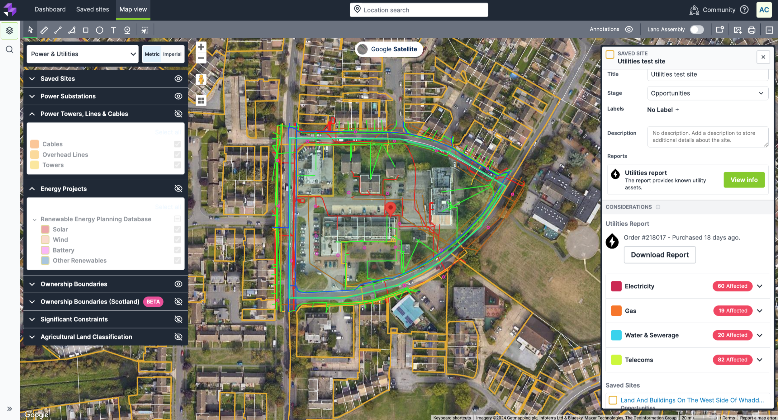
How does utility data provided by AtkinsRéalis integrate with LandTech?

Like all our platform enhancements, AtkinsRéalis utilities reports integrate seamlessly with LandTech.

Site sourcing

Utilty map data and reports supplied by AtkinsRéalis can be overlaid on your map and visualised alongside other important data to help you conduct an extensive site analysis in minutes. Utility data is just one of many data-sources you can access through LandTech, such as:

  • Planning applications
  • Current and emerging policy
  • Hazards and constraints
  • SHLAA
  • LPA activity
  • Power infrastructure
  • Sold prices and market valuations
  • Property and ownership information
  • … the list goes on!


Site management

In the same way you can see utilities data overlaid on the map, it will also be visible and accessible through your saved site card in your pipeline. This will make the report visible for all colleagues and stakeholders, improving access to information between collaborators. 

Screenshot 2024-03-19 at 10.51.22

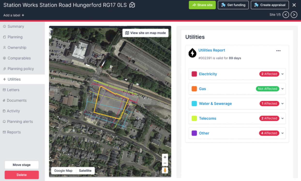
An example of how the AtkinsRéalis utility data can be accessed through a site card in LandInsight

Due diligence

In addition to visibility within your map layer, the utility data, viewed alongside the asset owners’ responses within the report, will help inform your site appraisals, allowing you to plan with confidence.


How to get started

To fully understand your needs and the challenges we think that the AtkinsRéalis utility map data/reports can help you solve, we’d love to have a quick chat with you,

Click the button below to provide us with a few details, and we’ll be right in touch

Find out more