
What is the Green Belt?
Prior to the General Election, the Labour Party had provided some rhetorical teasers about what they were thinking about in terms of green belt reform. Our analysis of this position and its possible impact is available here. Things have moved on a little now…
Policy updates
The draft NPPF, which was released for consultation in August, included the following definition for Grey Belt:
“Grey Belt: For the purposes of plan-making and decision-making, ‘Grey Belt’ is defined as land in the green belt comprising Previously Developed Land and any other parcels and/or areas of green belt land that make a limited contribution to the five green belt purposes (as defined in para 140 of this Framework), but excluding those areas or assets of particular importance listed in footnote 7 of this Framework (other than land designated as green belt).”
The NPPF also introduced a scenario through which land in the green belt can be developed, making it clear that in certain circumstances development in the green belt would not be inappropriate. These circumstances include those in which LPAs are unable to meet their housing delivery test, or maintain a five year supply of housing land.
This is potentially significant, but more on this later.
The key thing to note about the newly proposed definition of Grey Belt is that it has broadened the scope of potential Grey Belt land from just vacant, derelict, or previously developed land; and now includes any sites that make ‘limited contribution’ to the five purposes of green belt.
These five purposes of green belt, which remain unchanged in the draft NPPF are:
- to check the unrestricted sprawl of large built-up areas;
- to prevent neighbouring towns merging into one another;
- to assist in safeguarding the countryside from encroachment;
- to preserve the setting and special character of historic towns; and
- to assist in urban regeneration, by encouraging the recycling of derelict and other urban land.
With this understanding of the Grey Belt in mind, we’ll move on to how we approached our latest analysis of the Grey Belt.
A collaborative and data-driven approach
Following the release of the NPPF, we have redefined our approach to understanding and identifying the Grey Belt. Instead of pinpointing individual sites, we’ve now focused on broader areas where Grey Belt sites could be located, allowing us to better assess the potential impact of the updates to the NPPF.
We’ve gone back to the drawing board with our approach to defining and identifying the Grey Belt, and quantifying the potential impact of this policy change. Instead of looking for specific sites that may be considered to be Grey Belt, we have looked instead at areas in which Grey Belt sites may be located.
Taking a collaborative and data-driven approach, we’ve consulted with key industry experts, including specialists from leading green belt consultancies and the Greater London Assembly. These conversations helped us to fine tune our approach and find appropriate data points to act as proxies for the often-subjective and very detailed green belt assessments undertaken by, or on behalf of, local authorities.
The idea behind this is that this information can be combined with LandTech’s existing data on where the ‘presumption in favour’ may apply, to help identify and rank potential development sites (or sites that may be at risk of speculative development - depending on which way you look at it).
Identifying Grey Belt Sites
The starting point is to identify all green belt land that is not also affected by constraints listed in Footnote 7 of the NPPF. This gives us an ‘unconstrained green belt’ layer within which to commence stage two.
Stage two is to identify land that may not be meeting the five green belt purposes. We have introduced buffers around Historic Towns, and identified an approximate distance proxy that will allow a buffer to be introduced to avoid neighbouring towns from coalescing.
From the remaining areas we have removed sites that are not adjacent to existing built up areas to prevent isolated sites being suggested, and we have filtered to remove inappropriate sites such as linear infrastructure (roads and rail), parks, educational institutions, cemeteries, etc.
Ranking Grey Belt sites
This process identified a large number of sites that may be considered as Grey Belt, but not all of these will be suitable for development, and of the sites that may be suitable for development, not all of them will be equally suitable.
To address this, we have introduced a ranking system to highlight the sites that are more likely to be deemed acceptable as Grey Belt development sites. The ranking system considers: existing uses on the site, the affordability ratio of the area (i.e. average house price/average income), agricultural land grade, distance to nearest railway station or PTAL score, and distance to other local amenities.
The output of this process is a long list of ranked sites which may be considered as ‘Grey Belt’ development sites.
Standard Method for Calculating Housing Need
The changes proposed to the NPPF go beyond just the definition of Grey Belt, they introduce other scenarios where development in the Green Belt can happen. Changes proposed to how housing need is calculated mean that this scenario may become more common.
Paragraph 152 of the new draft NPPF makes it clear that if an LPA can’t meet its housing requirements, or fails to deliver 75% of its housing requirement as measured in the housing delivery test then development within the green belt is no longer inappropriate (provided it meets certain criteria).
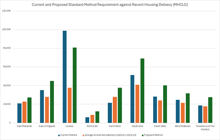
Alongside the new NPPF, the government is also consulting on an updated method for calculating housing need. There is enough to say about the impact of this change to justify its own blog article, and we’ll get to that in time. In the meantime, Lichfields have provided a useful summary of the potential impacts here.
Based on figures released by MHCLG to support this consultation, you can see which areas are likely to see an uplift in housing requirement, and which areas are likely to see a reduction in housing requirement, based on the updated Standard Method. You can also see how areas have been performing against the existing and proposed new housing requirements.
The long and the short of it is that, unless housing delivery sees a massive uptick in a wide range of areas, many LPAs are going to fall under the impact of the presumption of sustainable development, and the impact of paragraph 152 of the new NPPF - i.e. their green belt will be up for grabs.
We have done some calculations about where the LPAs are across the country that may now be at risk of falling under the presumption, watch this space for an update.
Where are the Grey Belt opportunities?
Our analysis has indicated that up to 150,000 ha of land may become a potential Grey Belt site should the draft NPPF be published in its consultation draft. Using some rough development metrics (60% development area) this could deliver between 2.5 million homes (at 30 dwellings per hectare) and 4 million homes (at 50 dwellings per hectare).

This could be a decade’s worth of housing land using less than 10% of the country’s total green belt area.
Using our favourability scale mentioned above, around 14,000 ha (c.250,000 - 400,000 homes depending on density) would be on land considered to be most favourable. Nearly 100,000 ha of land (between 1.5 million and 3 million homes) has average and above favourability, according to our scoring.

But this is only half the picture.
The new NPPF makes it clear that, aside from the disused car parks and petrol stations, development in the green belt will not be inappropriate where an LPA is unable to meet its housing delivery requirement or maintain a 5 year supply of housing land, in other words, where the presumption in favour of sustainable development is in play.
LandInsight provides an indication of where the presumption currently may already be a consideration. You can see where this is relevant using both the 2023 NPPF and the draft NPPF in our platform today.
We have used this data, along with a projection of where the presumption is likely to kick in in the future where LPAs are likely to be subject to increases in delivery requirement thanks to the updated Standard Method, to look at how much land may be open to speculative Grey Belt development; both immediately following the publication of the new NPPF, and in the future unless delivery picks up.
Our analysis indicates that the presumption may currently apply in 64 green belt affected LPAs. In these areas, Grey Belt development may be possible right away once the NPPF is finalised. These LPAs could provide around 50,000 ha of Grey Belt land, nearly 6,000 ha of which has been ranked as being most favourable and around 35,000 ha ranked as above average favourability.
Based on data from MHCLG, and our own analysis, we’ve predicted that the number of LPAs in which the presumption may apply is likely to increase to around 107 thanks to changes proposed to the Standard Method. These additional 43 LPAs could add an extra 35,000 ha of potential Grey Belt land; that’s another 600,000 to 1.2m additional homes (depending on density).

In total, in the 107 LPAs which are currently subject to the presumption, or are likely to become subject to the presumption, around 9,000 ha of land has been ranked as one of the ‘most favourable’ Grey Belt sites. Nearly 65,000 ha of land in these LPAs has been ranked at above average favourability; possibly delivering between 1m and 2m homes.
The future of housing delivery
In conclusion, the evolving definition of Grey Belt land presents significant opportunities for unlocking much-needed housing development. As policy updates and housing need calculations continue to shift, the potential to deliver millions of homes on previously overlooked land is becoming a reality.
To dive deeper into these opportunities and gain a better understanding of how to navigate this complex landscape, check out our on-demand webinar, Unlocking Development Opportunities with the Grey Belt. Watch the on-demand webinar now to stay ahead of the curve and explore the possibilities this land holds for future development.
