How to Find Out Who Owns Land: Land Registry, Companies House, and Faster Alternatives
You've spotted a promising development site. The plot ticks every box - size, location, planning potential. There's just one problem: you have no idea who owns it.
Maybe the Land Registry title shows a corporate name buried inside an SPV you've never heard of. Maybe the land has no postal address at all. Or maybe you're not looking at one site - you're looking at fifty, and you need answers by Friday.
Finding out land ownership in the UK isn't always straightforward, but it is entirely doable. The primary route is HM Land Registry, which holds ownership records for the vast majority of land and property in England and Wales. But Land Registry is just the starting point; tracing corporate structures, dealing with unregistered land, and doing any of this at scale requires a bit more know-how.
This guide covers how to find land ownership using Land Registry, when to bring Companies House into the picture, what to do when the land isn't registered, and how developers working across multiple sites can cut the process down from days to minutes.
Why Land Ownership Information Matters at the Site Sourcing Stage
Before diving into the how, it's worth being clear on the why - because ownership data does a lot more than just tell you who to call.
Freeholder vs leaseholder shapes the entire negotiation.
Buying the freehold is a very different conversation from acquiring a long leasehold, and the wrong assumption early on can waste months of time. Understanding the tenure from the outset means you can frame your approach correctly, structure your offer appropriately, and avoid the awkward situation of getting three months into heads of terms before realising the party you've been dealing with doesn't actually have the authority to sell.
Corporate ownership structures add a layer of complexity that catches a lot of developers out.
A title registered to a company name tells you very little on its own. You need to know who controls that company, whether it's part of a wider group, and - importantly - who actually makes the decisions. Many development sites are held inside SPVs (special purpose vehicles) set up specifically to hold one asset, and the individuals pulling the strings may be several layers removed from the registered title.
Boundary data matters just as much as the name on the title.
The registered boundary defines the exact extent of what you're potentially acquiring, and discrepancies between what you think you're buying and what's actually registered can be costly to unpick. Checking the title plan early avoids these surprises.
Ownership change alerts are where things get really interesting for proactive developers.
Knowing when a parcel of land changes hands before it's been publicly listed is one of the most reliable routes to off-market opportunity. More on that later.

How to Find Land Owner Information via HM Land Registry
If you want to find out who owns a piece of land in England or Wales, HM Land Registry is your first stop. It holds ownership records for the vast majority of land and property, and for most development sites it's where your search should begin.
Step-by-step: Land Registry check ownership
- Go to gov.uk/search-property-information-land-registry
- Search by postcode, street address, or using the map tool (more on that below)
- The free summary confirms whether the land is registered, gives you the title number, and shows the tenure type (freehold or leasehold)
- A title register costs £7 and gives you the full ownership details - the registered proprietor, any charges or mortgages secured against the land, and any covenants or restrictions
- A title plan also costs £7 and shows the registered boundary on an Ordnance Survey base map
- For land registry proof of ownership for legal purposes, you'll need an official copy (form OC1), which costs £11 by post
If you need to speak to someone directly, you can contact Land Registry UK via the official portal at gov.uk/contact-land-registry - useful if you're dealing with a complex title, an error in the register, or an urgent official copy request.
Find a land owner by map
For fields, brownfield plots, or any land without a postal address, the map search tool is far more practical than searching by address. It lets you select a parcel directly on the map and pull up its title information - and it's particularly useful when you want to understand the ownership pattern across a wider area rather than looking at a single named property. If you're assessing a cluster of plots that together could form a viable allocation, the map view lets you identify each title quickly and get a clear picture of how many separate landowners you'd be dealing with.
Understanding land registry property ownership records and changes of ownership
The title register is split into three parts. The A register covers property details - tenure, a brief description, and a reference to the title plan. The B register shows the current registered owner and, where relevant, the price paid and date of purchase. Land registry change of ownership data is recorded here too, so if a site has recently transferred between parties, the date and new registered proprietor will both be visible. The C register is where you'll find charges, mortgages, covenants, rights of way, and overage agreements - all of which could materially affect development viability.
It's worth reading all three sections carefully. Developers sometimes focus on the registered proprietor and miss something in the C register that significantly changes the value of the opportunity.
What if the land isn't registered?
Around 15% of land in England and Wales remains unregistered - compulsory registration only came into force in 1990, so older rural and agricultural land may never have been formally registered. For a land registry owner search on unregistered land, your options include:
- An index map search (form SIM, £4) - confirms whether a title is registered and gives you the title number if it is
- Local council records and planning portals, which sometimes hold historical ownership information
- Historical title deeds, which may be held by the landowner, a solicitor, or archived with the local authority
If unregistered land is sold, the new owner is required to register the title - so if a parcel suddenly appears on Land Registry for the first time, it's a reasonable signal that a transaction has recently occurred.

Corporate Ownership: When You Need Companies House Too
When a Land Registry title names a company rather than an individual, you've found the what - but not the who. To find the owner of land held within a corporate structure, Companies House is your next port of call. A free search at find-and-update.company-information.service.gov.uk will give you directors, registered address, and filing history, along with clues about any wider group structure.
For a broader land registry find owner search across a portfolio, HM Land Registry's Index of Proprietors' Names (form PN1) lets you search for all land registry property ownership registered to a specific company or individual - useful when you're trying to map a particular landowner's full holdings across a target area.
Institutional landowners frequently hold assets through layered structures, with the individuals who can actually authorise a sale several steps removed from the registered title. The Register of Overseas Entities, introduced under the Economic Crime Act 2022, has improved transparency for foreign-owned land by requiring overseas owners to declare beneficial ownership at Companies House.
How to Find a Land Owner: Beyond Land Registry
Not all ownership can be traced through Land Registry alone. Local council planning portals are worth checking - planning applications require ownership confirmation, so any site with planning history may name the owner directly. Aerial photography and boundary mapping tools help you understand a site's extent before spending money on formal data, and tools that let you find a land owner by map are particularly useful for working visually across a wider area. Local agents often hold knowledge for rural and agricultural land that the paper trail simply doesn't capture - in areas where land rarely changes hands, that local knowledge can bridge gaps that formal records leave open.
How Developers Find Land Ownership at Scale with LandInsight
If you're checking ownership on a handful of sites, the manual Land Registry process is manageable. If you're running a proper sourcing operation - assessing dozens or hundreds of parcels regularly - it quickly becomes a serious bottleneck. Individual £7 searches add up, but the bigger cost is time: logging in, searching, downloading, cross-referencing Companies House, and starting again for the next site.
LandInsight's Ownership layer is built specifically for that problem. Rather than running individual searches, it consolidates Land Registry and Companies House data into a single map view, updated monthly, overlaying ownership boundaries on Google, Satellite, and OS Maps. Clicking any parcel surfaces the ownership details directly - tenure type, title owner, last ownership change, and links to the title register and plan - without a separate search for each one.
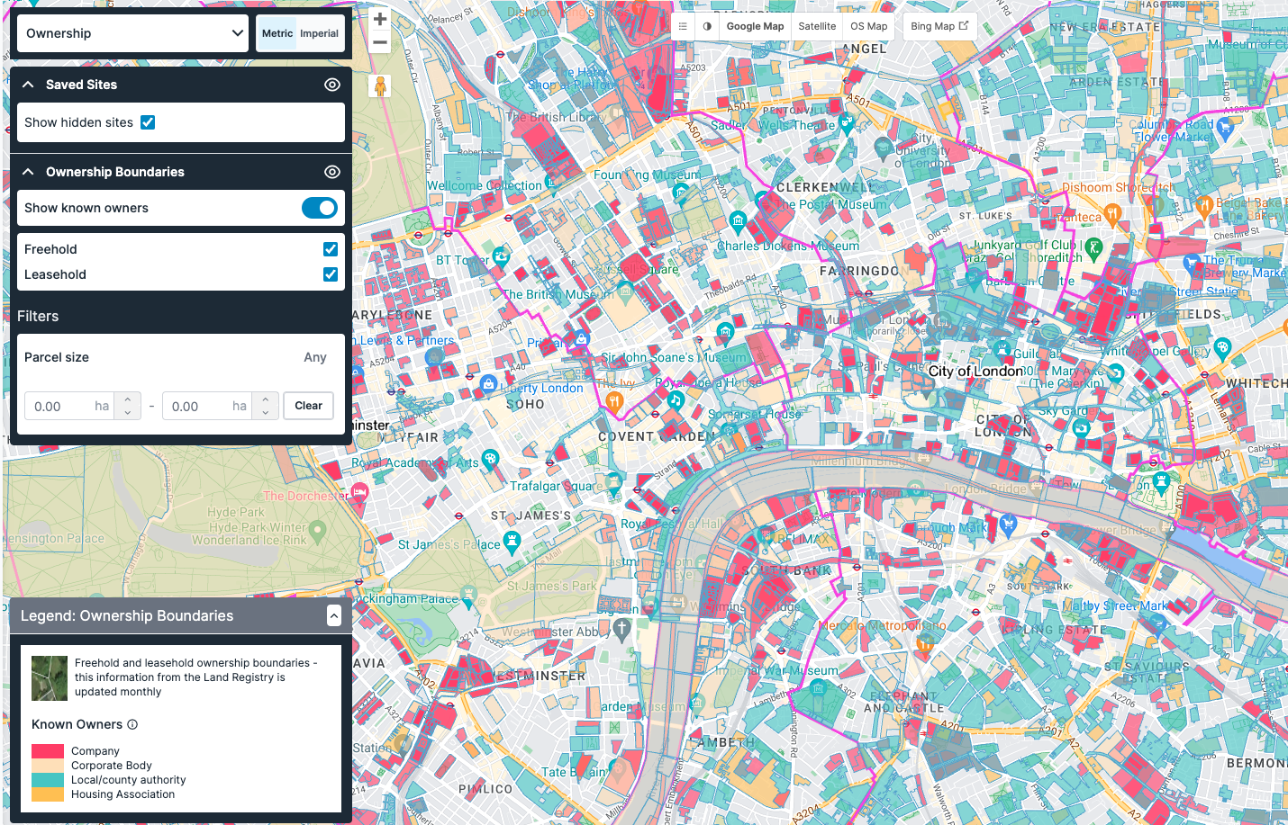
What it does that the manual process doesn't:
- Parcel size filtering - set a minimum and maximum site area to cut out anything that doesn't meet your brief before you've spent a minute on it. Size data is refreshed on the 6th of every month
- Tenure toggle - switch between freehold and leasehold views instantly depending on what you're targeting
- Ultimate owner identification - cuts through layered corporate structures to surface the controlling entity, without manually tracing through Companies House
- Ownership change alerts - emailed as soon as a parcel changes hands, so you can approach landowners before the site reaches the open market
- Site Sourcing Tool - bulk filtering by tenure, ownership type, and parcel size across large geographies, with results on the map and as a downloadable CSV for use in your own pipeline
- Sites Pipeline - save and manage shortlisted sites across the platform as you build your pipeline. Here are our top 10 tips on getting the most out of your sites pipeline
The underlying data is the same as what you'd get through official Land Registry searches - it's just surfaced in a way that works for people assessing multiple sites at once, not one at a time. For developers running an active sourcing pipeline, the difference between the two approaches isn't marginal. It's the difference between reacting to what reaches the market and getting there before it does.
FAQs
How do I find out who owns a piece of land with no address?
Use the Land Registry map search tool at gov.uk/search-property-information-land-registry to select a parcel directly rather than searching by address. For land that isn't registered, an index map search (form SIM, £4) will confirm whether a title exists.
How do I check ownership on Land Registry?
Go to gov.uk/search-property-information-land-registry and search by address, postcode, or map. A free summary confirms whether the land is registered. To check ownership Land Registry records in full — including the registered proprietor, charges, and covenants - the title register costs £7.
How to find owner of land held by a company?
Start with the Land Registry title register to identify the registered proprietor, then search Companies House for directors and corporate structure. For layered ownership, LandInsight's ultimate owner identification tool surfaces the controlling entity without manual Companies House tracing.
Can I find a land owner by map?
Yes. Both HM Land Registry's own portal and tools like LandInsight allow you to search and filter ownership data via an interactive map. This is particularly useful for fields, brownfield sites, and any land without a conventional address.
How much does a Land Registry ownership search cost?
A free summary confirms basic registration details. A full title register costs £7, a title plan costs £7, and an official copy for legal purposes costs £11. No subscription is required for one-off searches.
What if the land is not registered with Land Registry?
Around 15% of land in England and Wales is unregistered. An index map search (form SIM, £4) will confirm the position. Beyond that, check local council records, historical deeds, or speak to a solicitor familiar with the area.
How to find out land owner information for multiple sites?
For one-off searches, the manual Land Registry process is fine. For multiple sites, LandInsight aggregates Land Registry and Companies House data into a single interface with bulk filtering and CSV export - considerably faster than running individual searches.
Can I search for all land owned by one company or individual?
Yes - through the Index of Proprietors' Names (form PN1) via Land Registry, or via LandInsight's portfolio-level ownership search, which is faster if you're doing this regularly.
How long does a Land Registry search take?
Online searches are usually instant for registered land. Official copy requests by post (form OC1) typically take a few working days. LandInsight surfaces the same data in real time, without the individual search steps.
Once you’ve found the right sites using the filter or Site Sourcing feature, you’ll need to make sure you’re staying on top of your pipeline of opportunities. Across the entire platform, regardless of the data layer you’re using, you can easily save a site of interest with a few clicks using the Sites Pipeline.
Here’s our top 10 tips on getting the most out of your sites pipeline.
Ready to move faster?
For property developers who need ownership data across multiple sites, manually searching Land Registry one plot at a time isn't a viable workflow. LandInsight aggregates and layers this data so you can identify owners, filter by parcel size, trace corporate structures and set ownership change alerts - all in one platform.