How to mitigate risk and find opportunities with the Planning Policy layer

Picture of Andrea Duke

Andrea Duke
March 26, 2024
Read time: minute(s)

In the complex world of property development, understanding the intricacies of planning policies is not just beneficial - it's essential. These policies shape what’s actually possible to develop on a piece of land, influencing everything from the potential size of a development to its purpose. 

Recognising the critical role of evaluating planning policy in the development process, LandInsight’s Planning Policy layer takes a comprehensive approach to simplify the task of finding and interpreting these crucial pieces of information. 

This data layer is pivotal for developers who aim to navigate the regulatory landscape efficiently, turning potential hurdles into stepping stones towards successful project completion.


What is the Planning Policy layer?

LandInsight’s Planning Policy layer offers data that spans national, regional, and local levels, available for England, Scotland, and Wales, with detailed local data currently accessible for England and Wales. 

At its core, this layer breaks down the planning policy landscape into an easily digestible view, with each set of planning policy data colour coded and overlaid onto the map. You’ll have access to vital information ranging from planning constraints to environmental risks to help you quickly mitigate risk on any upcoming development - all before you submit your planning application. 


And because change is inevitable with planning policies, we ensure that any alterations are digitised and incorporated generally within a month, keeping you informed and ahead of the curve.

landinsight planning policy layer

What data is in the Planning Policy layer?

The Planning Policy layer is a comprehensive collection of significant constraints and policy designations that affect land development potential. Below is a full list of the data available in this view: 

  • Significant Constraints: Information on flood zones, flood risks, conservation areas, and protected areas like SSSIs, AONBs, SACs, SPAs, and Ramsar sites. This data helps developers assess environmental challenges and opportunities associated with a site.

  • Policy Designations: Details on settlement boundaries, Green Belt areas, nutrient and water neutrality requirements, and heritage land. This data is crucial for understanding the regulatory landscape and identifying areas with development constraints or incentives.

  • Local Planning Authority Data: Includes Community Infrastructure Levy (CIL) information and insights into local planning authority policies, such as the presumption in favour of sustainable development. This information aids in assessing the feasibility of planning applications based on current local policy standings.

  • Regeneration and Allocation Zones: Data on Area Action Plans, Named Regeneration Areas, Residential Allocations, and Site Allocations, offering a lens through which developers can identify areas targeted for development or regeneration.

  • Land Availability Assessments: Insights into SHLAAs, Brownfield Registers, and agricultural land classifications, among others, providing a clear picture of land promoted for development and its suitability.

  • Agricultural Land Classification (ALC): Managed by Natural England and Natural Resources Wales, this classification protects 'best and most versatile' (BMV) agricultural land from development. It's crucial for site feasibility assessments, with updates made periodically to ensure current data availability.

  • Neighbourhood Plan Areas: Established under the Localism Act 2011, neighbourhood plans outline local planning policies, aimed at protecting green spaces and promoting well-designed, community-focused housing developments. Data is sourced from the Department for Levelling Up, Homes and Communities (DLUHC) and the Office for National Statistics, with updates from LandTech occurring quarterly.

Best practices for maximising the Planning Policy layer

Integrating the Planning Policy layer as a part of your initial site sourcing and assessment process is critical to overcoming potential issues later down the line. In order to streamline your research and due diligence, here’s a few quick tips to maximise the Planning Policy layer:

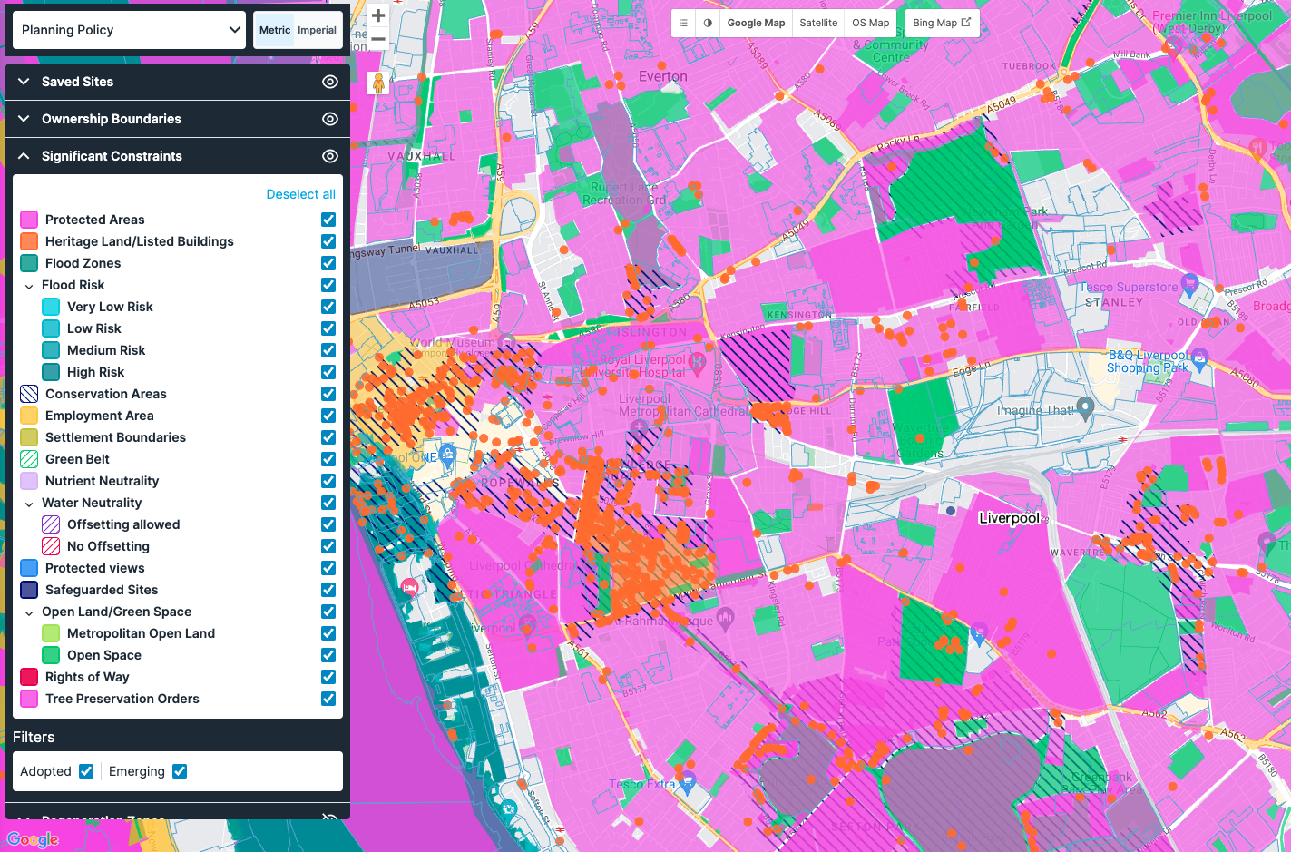
  • Utilise Filtering and Toggling: Engage with different datasets to refine search results based on specific constraints or opportunities, such as flood risk, conservation status, or agricultural land classification. You can toggle on and off these filters to unveil the best opportunities. 

  • Leverage the Site Sourcing Tool: Filter for various factors, including local availability assessments, adopted and emerging proposals, alongside detailed information like ownership type, parcel size, tenure, and use class. This way, you’ll find the best opportunities that avoid potential planning issues.


Ready to get started?

LandInsight's Planning Policy layer stands as a pivotal tool in the arsenal of property developers, offering an unparalleled depth of information that breaks down the planning policy landscape. In using this layer, developers can not only identify viable development opportunities, but also quickly dismiss unsuitable sites, helping to strategically position their projects for success. 

And even better, it’s just one of many layers within LandInsight that can help get you up to speed. 

Check out our free eBook, The Seven Building Blocks to Success: A Property Developer’s Guide to LandInsight, to take a deeper look at all the data available in LandInsight and how it can help you streamline your site sourcing. 


Download Now