
What is in the new Act?
The Levelling Up and Regeneration Act received Royal Assent in October, paving the way for wide-ranging changes to the UK planning system. The Secondary Legislation, which will give effect to the new Act, will come over the next few months. While this is being finalised, we’ve looked in more detail at the ‘data standards’ provisions in the new law.
In this blog, we’ve unpacked what these changes are and what they will mean for developers.
Part 77 of the Levelling Up and Regeneration Act requires certain planning data to be made publicly available, the Act stipulates that:
- Planning data regulations may make provision requiring a relevant planning authority to make such of its planning data as is specified or described in the regulations available to the public under an approved open licence.
- The power under subsection (1) does not include power to require a relevant planning authority to make planning data available in breach of— (a) any obligation of confidence owed by the authority, or (b) any other restriction on making the planning data available (however imposed).
- An "approved open licence", in relation to a planning authority's planning data, means a licence— (a) which sets out terms and conditions under which the planning data may be used by the public free of charge, and (b) which is in such form and has such content as is, for the time being, specified or described in a document published by the Secretary of State.
Part 78 of the Act provides the power to require use of approved planning data software in England and states:
- Planning data regulations may make provision restricting or preventing a relevant planning authority in England from using or creating, or having any right in relation to, planning data software which— (a) is specified or described in the regulations for the purposes of this subsection, but (b) is not approved in writing by the Secretary of State.
- "Planning data software" means software which is capable of being used for the purposes of enabling or facilitating the provision of planning data to, or the processing of planning data by, relevant planning authorities.
Put simply, these provisions give the government powers to require planning data to be made ‘open’, available, and free for the public to use, and give the government the ability to stipulate what software is used to interpret planning data. This may seem like a small change but it will have an impact, and not just for companies like us who are in the business of providing data to our customers.
What are Data Standards and why are they important?
One of the things that must form part of the suite of secondary legislation that supports the new Act will be a direction on data standards.
A requirement that data is provided in a specific way may seem like an arcane and obscure thing to mandate, but ensuring that the industry is speaking the same language, and that information is transferable and universally understandable, is a vital step to building a 21st-century planning system.
A mandated and enforced direction on data standards will have numerous benefits, including (most significantly) long-term cost reductions. One of the biggest ongoing costs in data management relates to ensuring that data is collected and supplied in a consistent and understandable way. Getting this right at the outset saves costs in having to retroactively clean data, and also saves potential lost-opportunity costs where incorrect or inaccurate data has been used, leading to missed potential.
The common framework for data that will be created following this Act will allow information systems, like the planning system, to become properly scalable - addressing the chronic inertia that has been slowing down the more widespread digital adoption that has been applied to most other areas that the government interacts with the public.
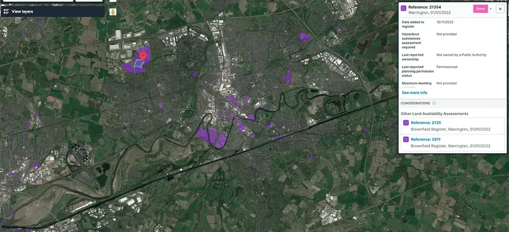
What could go wrong? – the Brownfield Land register Case Study
The Brownfield Land Register is a key dataset in the context of planning and the brownfield-first principle described in the NPPF. It identifies previously developed land which may be suitable for residential development, and which has a much higher chance of being approved at planning. All planning authorities in England are required to maintain these registers.
The data has been collated ‘as-is’ by the team at planning.data.gov.uk, and the lack of enforced data standards (though published standards do exist) means that the spatial quality of the data is highly variable, with many thousands of records being incorrectly located, whether through incorrect conversions of coordinates between projections, swapping of coordinate order, missing coordinates entirely or through oversimplification of coordinates.
The impact of this is that sites may appear in the sea, in different countries, or, perhaps most concerning, just inaccurately mapped near where they should be but sometimes hundreds or even thousands of metres away from their actual location.
When LandTech looked to adopt this data set and show it in LandInsight over 4,000 records (from a total of nearly 23,000 - over 17%) had to be manually or systematically corrected (as appropriate) by our data team in order to make the data usable.
Any remaining ambiguity was dealt with by contacting the local authorities in question and digging down until we found the source of truth. In several cases, our investigations led to authorities having to republish their register to correct the errors that our team identified.
As a result, the data in LandInsight represents the cleanest, most accurate data that can be found in any Prop Tech platform.
What makes LandTech different?
So, what is it that makes LandTech different from our competitors that are now offering different ways to view planning data?
Firstly, we have a dedicated data team. The role that the data team played in ensuring that the information that we provide our customers is as good as it can be should be obvious from the above Brownfield Register case study.
Our data team means that not only can we provide the data to you, but we actually know what it means. As a result, where there are errors in the underlying data, we can spot them and fix them before we serve them up to you.
We are able to use this knowledge about how the data works to make important edits and additions to ensure that it’s useful. Not just regurgitating information, but curating, analysing, and considering what our customers actually need to know.
Sometimes having too much data can be as bad as having too little, we’re able to see through the noise to provide the analysis that our customers need to make important strategic decisions.
Why are we talking about this now?
Data scientists talk about the ‘five Vs’ of data; these Vs relate to the Velocity, Volume, Value, Variety, and Veracity of data. The Levelling Up and Regeneration Act should pave the way for all of these attributes to improve, which in turn will increase the speed at which data is commoditised, and the speed at which decisions can be made.
Until the new data standard regulations are made, we - along with the rest of the industry - are reliant on the planning data that we have available.
Our customers rely on the veracity (trustworthiness) of data as well as its velocity (speed). Until the data standards are standardised, and the data on which you make your decisions is automated to a much greater level, having data experts on your team is a vital edge that you really can’t afford to be without.
Read more in our blog about all the great work our data team does to bring data into LandInsight from a wide range of sources – Where does LandTech get its data?